IMAGES TAKEN NEAR TO
Watnall, NOTTINGHAM, NG16 1JA
Introduction
This page details the photographs taken nearby to NG16 1JA by members of the Geograph project.
The Geograph project started in 2005 with the aim of publishing, organising and preserving representative images for every square kilometre of Great Britain, Ireland and the Isle of Man.

There are currently over 7.5m images from over14,400 individuals and you can help contribute to the project by visiting https://www.geograph.org.uk
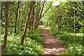
Image Map
Images are licensed for reuse under creativecommons.org/licenses/by-sa/2.0
Notes
- Clicking on the map will re-center to the selected point.
- The higher the marker number, the further away the image location is from the centre of the postcode.
Image Listing (13 Images Found)
Images are licensed for reuse under creativecommons.org/licenses/by-sa/2.0
Image
Details
Distance
1
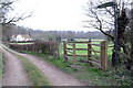
Footpath to Kimberley
Just off the B600.
Image: © David Lally
Taken: 15 Mar 2008
0.03 miles
2
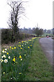
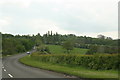
Daffodils on the B600
Greasley Church stands in the centre of the picture.
Image: © David Lally
Taken: 15 Mar 2008
0.09 miles
3
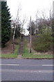
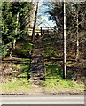
Footpath to Church Road
This short flight of steps leads between the B600 and the old path of the road between Watnall and Greasby.
Image: © David Lally
Taken: 15 Mar 2008
0.12 miles
4
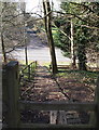
Church Road Steps, Watnall Chaworth NG16, Notts.
An 8ft wide path at the side of Hillendale House (a private house), off Church Road, leads walkers to the top of this flight of steps. A walking route leads ramblers down these steps onto the side of the B600 (main Greasley-Watnall road) and across the road.
Image: © David Hallam-Jones
Taken: 14 Mar 2013
0.12 miles
5
Church Road Steps, Watnall Chaworth NG16, Notts.
A local rambler's route leads walkers from Gilt Brook (a stream)'onwards and upwards' to the side of the B600 road (the main road between Greasley-Watnall) The route takes walkers across this busy road and up these steps to reach an 8ft wide path at the side of Hillendale House (a private house) on Church Road.
Image: © David Hallam-Jones
Taken: 14 Mar 2013
0.12 miles
6
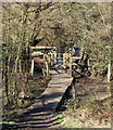
Footbridge across Gilt Brook, Bogend NG16, Notts.
Gilt Brook can be crossed here in the valley below Wood Villa. The area is frequently marshy underfoot, hence the wooden walkways. Greasley Church soon comes into view - across fields to the right - on the other side of the brook and through these trees.
Image: © David Hallam-Jones
Taken: 14 Mar 2013
0.15 miles
7
Looking down the B600 from the junction with Church Road
Image: © Chris
Taken: 13 May 2014
0.16 miles
8
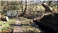
Gilt Brook, Bogend NG16, Notts.
A footpath from the Newthorpe area is likely to have led walkers to this footbridge across the brook. Once on the bridge, turning to the left leads ramblers towards Beauvale or Greasley, whilst turning to the right and then gently uphill across a grassy field leads walkers towards Watnall Charworth.
Image: © David Hallam-Jones
Taken: 14 Mar 2013
0.16 miles
10
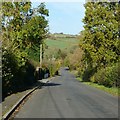
Church Road, approaching Bogend near Watnall
Formerly the A613 Nottingham to Alfreton road, a new bypass section was built c.1970.
Image: © Alan Murray-Rust
Taken: 2 Nov 2018
0.16 miles