IMAGES TAKEN NEAR TO
Trough Road, NOTTINGHAM, NG16 1HQ
Introduction
This page details the photographs taken nearby to Trough Road, NG16 1HQ by members of the Geograph project.
The Geograph project started in 2005 with the aim of publishing, organising and preserving representative images for every square kilometre of Great Britain, Ireland and the Isle of Man.

There are currently over 7.5m images from over14,400 individuals and you can help contribute to the project by visiting https://www.geograph.org.uk
Image Map
Images are licensed for reuse under creativecommons.org/licenses/by-sa/2.0
Notes
- Clicking on the map will re-center to the selected point.
- The higher the marker number, the further away the image location is from the centre of the postcode.
Image Listing (17 Images Found)
Images are licensed for reuse under creativecommons.org/licenses/by-sa/2.0
Image
Details
Distance
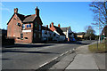
5
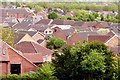
Watnall roofscape
Modern housing to the north of the village
Image: © Graham Hogg
Taken: 12 May 2015
0.10 miles
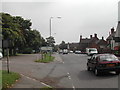

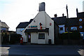
8
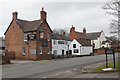
The Royal Oak, Watnall
This pub on the B600 between Nuthall and Underwood was built in 1758 and extended in 1889. It was extensively refurbished in 2016. The former RAF station, immediately across the road, provided much of its custom in the Second World War.
Image: © Stephen McKay
Taken: 11 Mar 2018
0.13 miles