IMAGES TAKEN NEAR TO
Carterswood Drive, NOTTINGHAM, NG16 1AS
Introduction
This page details the photographs taken nearby to Carterswood Drive, NG16 1AS by members of the Geograph project.
The Geograph project started in 2005 with the aim of publishing, organising and preserving representative images for every square kilometre of Great Britain, Ireland and the Isle of Man.

There are currently over 7.5m images from over14,400 individuals and you can help contribute to the project by visiting https://www.geograph.org.uk
Image Map
Images are licensed for reuse under creativecommons.org/licenses/by-sa/2.0
Notes
- Clicking on the map will re-center to the selected point.
- The higher the marker number, the further away the image location is from the centre of the postcode.
Image Listing (34 Images Found)
Images are licensed for reuse under creativecommons.org/licenses/by-sa/2.0
Image
Details
Distance
1
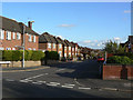
Temple Nuthall estate
Seen from Broxtowe Country Park. Different stages of construction can be clearly seen in this view, with the right hand rows of houses being later than those to the left.
Image: © Alan Murray-Rust
Taken: 25 Oct 2009
0.08 miles
2
Assarts Road, Nuthall
The top end of the Temple Nuthall development, dating from the early 1970s.
Image: © Alan Murray-Rust
Taken: 25 Oct 2009
0.09 miles
3
Highfield Road
Part of the Temple Nuthall development, started in the late 1930s and continued after the war. This is part of the early development and consists largely of detached houses, many in Tudorbethan style.
Image: © Alan Murray-Rust
Taken: 25 Oct 2009
0.11 miles
4
Cedarlands Crescent
Although this is the nearest part of the Temple Nuthall development to Nottingham, it was in fact developed later than the area a bit further west, as can be seen by comparing the architecture http://www.geograph.org.uk/photo/1556640 .
Image: © Alan Murray-Rust
Taken: 25 Oct 2009
0.13 miles
5
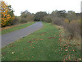
The path into Broxtowe Country Park
The path follows the line of the old colliery railway to Broxtowe Colliery; this was based on some of the oldest colliery tramways in the area.
Image: © Alan Murray-Rust
Taken: 25 Oct 2009
0.17 miles
6
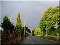
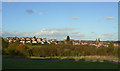
Storm clouds over Nottingham
Torrential rain, thunder and lightning have just passed over Nuthall, heading towards the city centre for the second day running. One of the main shopping centres, the Broadmarsh, had to be closed the previous day because of flooding.
Image: © Lynne Kirton
Taken: 16 Jun 2007
0.17 miles
7
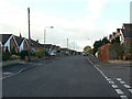
Woodland Drive, Nuthall
Off Nottingham Road.
Image: © JThomas
Taken: 27 Mar 2017
0.17 miles
8
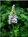
Common Spotted Orchid (Dactylorhiza fuchsii)
This handsome (and definitely wild) specimen suddenly appeared in our back garden! Not its usual habitat, which would normally be open woods, meadows, fens, marshes and scrubland.
Image: © Lynne Kirton
Taken: 10 Jun 2007
0.18 miles
9
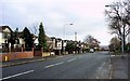
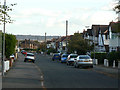
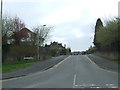
Nottingham Road, Nuthall
Taken at noon, New Year's Day 2006. Just outside the Nottingham city boundary, Nottingham Road used to be one of the main routes out of Nottingham to the west until the A610 bypass was built. Looking ESE.
Image: © Lynne Kirton
Taken: 1 Jan 2006
0.18 miles
10
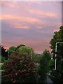
Evening Sky over Nuthall
Nuthall lies just outside the Nottingham City boundary close to M1 junction 26
Image: © Lynne Kirton
Taken: 5 Jun 2005
0.18 miles