IMAGES TAKEN NEAR TO
Tollhouse Hill, NOTTINGHAM, NG1 5FS
Introduction
This page details the photographs taken nearby to Tollhouse Hill, NG1 5FS by members of the Geograph project.
The Geograph project started in 2005 with the aim of publishing, organising and preserving representative images for every square kilometre of Great Britain, Ireland and the Isle of Man.

There are currently over 7.5m images from over14,400 individuals and you can help contribute to the project by visiting https://www.geograph.org.uk
Image Map
Images are licensed for reuse under creativecommons.org/licenses/by-sa/2.0
Notes
- Clicking on the map will re-center to the selected point.
- The higher the marker number, the further away the image location is from the centre of the postcode.
Image Listing (1200 Images Found)
Images are licensed for reuse under creativecommons.org/licenses/by-sa/2.0
Image
Details
Distance
2
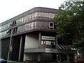
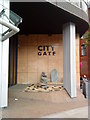
City Gate, Derby Road, Nottingham
An irregular seven-sided office complex enclosing a courtyard. All pretty slick with flush facades. It is joined by a bridge across Tollhouse Hill to a smaller irregular six-sided block with interesting street-level cladding (Image]). By Ian Fraser, John Roberts & Partners, 1973-76.
Image: © Stephen Richards
Taken: 18 Jun 2012
0.02 miles
3
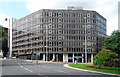
Upper Parliament Street: on the 77 bus
The bus from which the picture was taken was about to pull away from the stop and take the middle lane round the roundabout at the end of Maid Marian Way before going up Derby Road (to the right).
Image: © John Sutton
Taken: 25 Sep 2015
0.03 miles
5
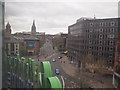
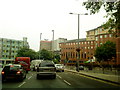
Nottingham - NG1
Three or four cars and a bus descend Tollhouse Hill towards the city centre whilst in the distance a handful of other vehicles can be seen disappearing uphill on Derby Road (A610) in an outbound direction. The spire of the Roman Catholic cathedral and the tower of the Albert Hall (the concert venue) are visible on the left.
Image: © David Hallam-Jones
Taken: 28 Apr 2012
0.04 miles
6
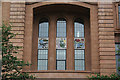
Decorative panels, Co-op House
These panels are set above the main entrance to what use to be the Co-op Department Store on Upper Parliament Street. Changes in the pattern of retailing in the City centre meant that this store became relatively stranded from the main retail core, and the business was closed down. The building now houses a casino, which does not fit well with the scenes of working people portrayed on the panels.
Image: © Alan Murray-Rust
Taken: 22 Jun 2007
0.04 miles
8
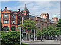
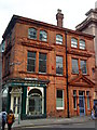
Former Co-operative Society, Upper Parliament Street, Nottingham
A fine ensemble. The nearer red-brick building was built for the Cahn's Nottingham Furnishing Company in 1906 by John Howitt. The adjacent seven-bay terracotta section, by William V. Betts, dates from 1914-16, and Betts returned to add the final section with its copper dome in 1925-26. Why isn't it listed?
The whole group was brought under the Co-op banner after 1945. It was converted to shops, offices and flats in 2005-07.
Image: © Stephen Richards
Taken: 18 Jun 2012
0.04 miles
9
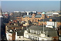
View from the Eye (12)
Looking north east. The building prominent in the centre is the former Cooperative department store, now a casino. Behind this to the left the black building is City Gate, a modern office development. The spire of Pugin's Roman Catholic Cathedral just creeps in at the left hand edge. The flagpoles stand on top of the Debenhams (formerly Griffin and Spalding) department store.
For views from the Nottingham Eye see http://www.geograph.org.uk/search.php?i=2274643 . To add your views to the slide show, simply ensure that the title or description includes 'View from the Eye’.
Image: © Alan Murray-Rust
Taken: 17 Feb 2008
0.05 miles