IMAGES TAKEN NEAR TO
The Ropewalk, NOTTINGHAM, NG1 5DU
Introduction
This page details the photographs taken nearby to The Ropewalk, NG1 5DU by members of the Geograph project.
The Geograph project started in 2005 with the aim of publishing, organising and preserving representative images for every square kilometre of Great Britain, Ireland and the Isle of Man.

There are currently over 7.5m images from over14,400 individuals and you can help contribute to the project by visiting https://www.geograph.org.uk
Image Map
Images are licensed for reuse under creativecommons.org/licenses/by-sa/2.0
Notes
- Clicking on the map will re-center to the selected point.
- The higher the marker number, the further away the image location is from the centre of the postcode.
Image Listing (536 Images Found)
Images are licensed for reuse under creativecommons.org/licenses/by-sa/2.0
Image
Details
Distance
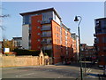
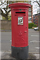
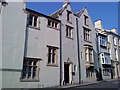
2
The Ropewalk
Looking up The Ropewalk at the junction with Upper College Street. A closer view of the postbox can be seen here: Image
Image: © Mark Anderson
Taken: 28 Apr 2012
0.02 miles
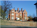
3
Nottingham - NG1
The former Park Waterworks complex (a.k.a. The Sion Hill Waterworks) on the northeast side of The Ropewalk. This building was constructed in Early English style in 1850 while Thomas Hawksley (1807-93), of Arnold) was Nottingham Waterworks Company's engineer. It was decommissioned in 1880 when it was found that its water supply was contaminated by water draining from the General Cemetery on Derby Road. Records show that a windmill occupied this site until about 1832. A large part of this building, that has now been adapted for commercial purposes, is currently un-let. Derby Road appears on the horizon.
Image: © David Hallam-Jones
Taken: 5 May 2012
0.02 miles
5
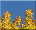
Autumn leaves, October 2022 ? 5
Sycamore spikes
Image: © Alan Murray-Rust
Taken: 18 Oct 2022
0.02 miles
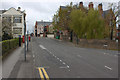
6
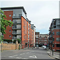
Upper College Street
Looking down the hill from The Ropewalk to Derby Road.
Image: © John Sutton
Taken: 26 May 2014
0.03 miles
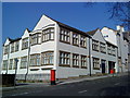
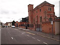
9

Nottingham, NG1 - Upper College St
The junction of Upper College Street - nearest the photographer - and College Street that is hosting a parked car pointing down it (it is a hill), towards Wellington Circus. The gates inn the centre of the picture are situated at the top of several flights of steps leading down to "The Park Tunnel", a 19th century footpath created beneath the rocks above it. It runs from Tunnel Road to Derby Road (A610). The spire of St Martin's Roman Catholic Cathedral is also visible.
Image: © David Hallam-Jones
Taken: 11 Nov 2012
0.03 miles