IMAGES TAKEN NEAR TO
Main Road, NG15 9JW
Introduction
This page details the photographs taken nearby to Main Road, NG15 9JW by members of the Geograph project.
The Geograph project started in 2005 with the aim of publishing, organising and preserving representative images for every square kilometre of Great Britain, Ireland and the Isle of Man.

There are currently over 7.5m images from over14,400 individuals and you can help contribute to the project by visiting https://www.geograph.org.uk
Image Map
Images are licensed for reuse under creativecommons.org/licenses/by-sa/2.0
Notes
- Clicking on the map will re-center to the selected point.
- The higher the marker number, the further away the image location is from the centre of the postcode.
Image Listing (4 Images Found)
Images are licensed for reuse under creativecommons.org/licenses/by-sa/2.0
Image
Details
Distance
1
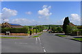
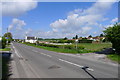
Haddon Road joining Hereford Road, Ravenshead
Cycle Route 6 through the well ordered village of Ravenshead. Harlow Wood is on the horizon
Image: © Tim Heaton
Taken: 19 May 2013
0.17 miles
2
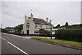
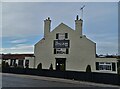
Looking towards the Little John Inn on the B6020, Ravenshead
Cycle Route 6 leaves Ravenshead (left) by crossing the road and taking the lane on the right. The pub's name reflects the area's association with Sherwood Forest and Robin Hood
Image: © Tim Heaton
Taken: 19 May 2013
0.22 miles