IMAGES TAKEN NEAR TO
Nottingham Road, NOTTINGHAM, NG15 9HG
Introduction
This page details the photographs taken nearby to Nottingham Road, NG15 9HG by members of the Geograph project.
The Geograph project started in 2005 with the aim of publishing, organising and preserving representative images for every square kilometre of Great Britain, Ireland and the Isle of Man.

There are currently over 7.5m images from over14,400 individuals and you can help contribute to the project by visiting https://www.geograph.org.uk
Image Map
Images are licensed for reuse under creativecommons.org/licenses/by-sa/2.0
Notes
- Clicking on the map will re-center to the selected point.
- The higher the marker number, the further away the image location is from the centre of the postcode.
Image Listing (5 Images Found)
Images are licensed for reuse under creativecommons.org/licenses/by-sa/2.0
Image
Details
Distance
1
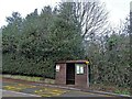
Bus stop with digital display
Beside the A60 near Ravenshead.
Image: © David Lally
Taken: 27 May 2018
0.03 miles
2
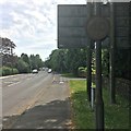
Very dirty speed limit
Beside the A60 at Ravenshead.
Image: © David Lally
Taken: 27 May 2018
0.18 miles
3
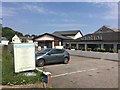
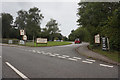
Santini and Sainsbury's
Restaurant and convenience store at the junction of the A60 and B6020.
Image: © David Lally
Taken: 27 May 2018
0.22 miles