IMAGES TAKEN NEAR TO
Main Road, NOTTINGHAM, NG15 9GX
Introduction
This page details the photographs taken nearby to Main Road, NG15 9GX by members of the Geograph project.
The Geograph project started in 2005 with the aim of publishing, organising and preserving representative images for every square kilometre of Great Britain, Ireland and the Isle of Man.

There are currently over 7.5m images from over14,400 individuals and you can help contribute to the project by visiting https://www.geograph.org.uk
Image Map
Images are licensed for reuse under creativecommons.org/licenses/by-sa/2.0
Notes
- Clicking on the map will re-center to the selected point.
- The higher the marker number, the further away the image location is from the centre of the postcode.
Image Listing (10 Images Found)
Images are licensed for reuse under creativecommons.org/licenses/by-sa/2.0
Image
Details
Distance
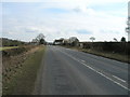
1
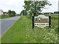
Ravenshead village sign, Main Road
This is the road from Blidworth. The sign depicts the front of Newstead Abbey.
Image: © Alan Murray-Rust
Taken: 1 Jun 2014
0.05 miles
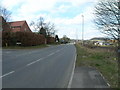
7
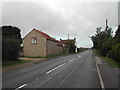
Cottage Farm
viewed west along Main Road, Ravenshead
Image: © Tom Courtney
Taken: 25 Sep 2005
0.20 miles
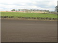
10
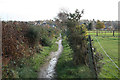
Sandy Lane
NCN route 6 on Sandy Lane bridleway between Ravenshead and Rickett Lane
Image: © Richard Croft
Taken: 25 Nov 2011
0.24 miles