IMAGES TAKEN NEAR TO
Haslemere Gardens, NOTTINGHAM, NG15 9FW
Introduction
This page details the photographs taken nearby to Haslemere Gardens, NG15 9FW by members of the Geograph project.
The Geograph project started in 2005 with the aim of publishing, organising and preserving representative images for every square kilometre of Great Britain, Ireland and the Isle of Man.

There are currently over 7.5m images from over14,400 individuals and you can help contribute to the project by visiting https://www.geograph.org.uk
Image Map
Images are licensed for reuse under creativecommons.org/licenses/by-sa/2.0
Notes
- Clicking on the map will re-center to the selected point.
- The higher the marker number, the further away the image location is from the centre of the postcode.
Image Listing (3 Images Found)
Images are licensed for reuse under creativecommons.org/licenses/by-sa/2.0
Image
Details
Distance
1
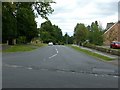
Church Drive, Ravenshead
It forms part of National Cycle Route 6.
Image: © Alan Murray-Rust
Taken: 15 Sep 2019
0.21 miles
2

Church of St Peter, Ravenshead
Dedicated in April 1972, this was a new church reflecting the enormous expansion of Ravenshead after World War 2. The design reflected the trend towards a more corporate liturgy with a forward altar. The roof of the body of the church is in the form of a hyperbolic paraboloid, by one of the UK's principal exponents, Hugh Tottenham. The church was Listed Grade II in 2018.
Image: © Alan Murray-Rust
Taken: 15 Sep 2019
0.25 miles
3

Church of St Peter, Ravenshead
Dedicated in April 1972, this was a new church reflecting the enormous expansion of Ravenshead after World War 2. The design reflected the trend towards a more corporate liturgy with a forward altar. The roof of the body of the church is in the form of a hyperbolic paraboloid, by one of the UK's principal exponents, Hugh Tottenham. The church was Listed Grade II in 2018.
Image: © Alan Murray-Rust
Taken: 15 Sep 2019
0.25 miles