IMAGES TAKEN NEAR TO
Sheepwalk Lane, NOTTINGHAM, NG15 9FD
Introduction
This page details the photographs taken nearby to Sheepwalk Lane, NG15 9FD by members of the Geograph project.
The Geograph project started in 2005 with the aim of publishing, organising and preserving representative images for every square kilometre of Great Britain, Ireland and the Isle of Man.

There are currently over 7.5m images from over14,400 individuals and you can help contribute to the project by visiting https://www.geograph.org.uk
Image Map
Images are licensed for reuse under creativecommons.org/licenses/by-sa/2.0
Notes
- Clicking on the map will re-center to the selected point.
- The higher the marker number, the further away the image location is from the centre of the postcode.
Image Listing (23 Images Found)
Images are licensed for reuse under creativecommons.org/licenses/by-sa/2.0
Image
Details
Distance
1
The church of St. Peter, Ravenshead
Image: © Jonathan Thacker
Taken: 10 Mar 2020
0.11 miles
2
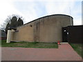
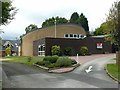
Church of St Peter, Ravenshead
Dedicated in April 1972, this was a new church reflecting the enormous expansion of Ravenshead after World War 2. The design reflected the trend towards a more corporate liturgy with a forward altar. The roof of the body of the church is in the form of a hyperbolic paraboloid, by one of the UK's principal exponents, Hugh Tottenham. The church was Listed Grade II in 2018.
Image: © Alan Murray-Rust
Taken: 15 Sep 2019
0.11 miles
3
Church of St Peter, Ravenshead
Dedicated in April 1972, this was a new church reflecting the enormous expansion of Ravenshead after World War 2. The design reflected the trend towards a more corporate liturgy with a forward altar. The roof of the body of the church is in the form of a hyperbolic paraboloid, by one of the UK's principal exponents, Hugh Tottenham. The church was Listed Grade II in 2018.
Image: © Alan Murray-Rust
Taken: 15 Sep 2019
0.11 miles
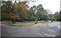
4
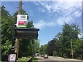
Bus stop with digital display
Beside the A60 near Ravenshead.
Image: © David Lally
Taken: 27 May 2018
0.16 miles
5
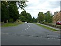
Church Drive, Ravenshead
It forms part of National Cycle Route 6.
Image: © Alan Murray-Rust
Taken: 15 Sep 2019
0.17 miles
6
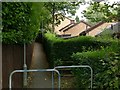
Footpath in Ravenshead
Running from the road junction at The Hutt to Sheepwalk Lane. It forms part of National Cycle Route 6.
Image: © Alan Murray-Rust
Taken: 15 Sep 2019
0.19 miles
8
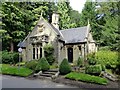
Newstead Abbey East Lodge, Ravenshead
At the main entrance to the Abbey from the Mansfield Road at Ravenshead. Erected 1862 after the estate was purchased by William Webb, designed by C A Buckler. Listed Grade II.
Image: © Alan Murray-Rust
Taken: 13 Sep 2019
0.20 miles
9
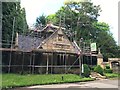
East Lodge Newstead Abbey, under scaffolding
Dates from 1862 and has a Grade II listing. List Entry Number: 1227515 https://historicengland.org.uk/listing/the-list/list-entry/1227515
Image: © David Lally
Taken: 11 Jul 2020
0.21 miles
10

The Pilgrim Oak
This handsome old oak tree stands at the main entrance to Newstead Abbey (which was actually a Priory). It is also sometimes known as 'The Gospel Oak', as pilgrims making their way to the Priory would stop and read the Gospels here before going down to the Priory. It was also used as a venue for local festivals.
I have been unable to find out the age of the tree, but it was already a notable specimen in Byron's time, and was described as 'a venerable tree, of great size' by Washington Irving when he visited the area in the early 19th century.
In autumn colours, it stands out nicely; at other times of year it tends to blend in to the background.
Image: © Antony Dixon
Taken: 11 Nov 2012
0.21 miles