IMAGES TAKEN NEAR TO
Birchwood Drive, NOTTINGHAM, NG15 9EE
Introduction
This page details the photographs taken nearby to Birchwood Drive, NG15 9EE by members of the Geograph project.
The Geograph project started in 2005 with the aim of publishing, organising and preserving representative images for every square kilometre of Great Britain, Ireland and the Isle of Man.

There are currently over 7.5m images from over14,400 individuals and you can help contribute to the project by visiting https://www.geograph.org.uk
Image Map
Images are licensed for reuse under creativecommons.org/licenses/by-sa/2.0
Notes
- Clicking on the map will re-center to the selected point.
- The higher the marker number, the further away the image location is from the centre of the postcode.
Image Listing (4 Images Found)
Images are licensed for reuse under creativecommons.org/licenses/by-sa/2.0
Image
Details
Distance
1
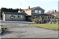
Sherwood Ranger Pub, Ravenshead
On Chapel Lane.
Image: © J.Hannan-Briggs
Taken: 17 Feb 2013
0.19 miles
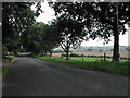
3
Ravenshead across the field from Robin Hood Way
Image: © Chris Morgan
Taken: 4 Apr 2016
0.22 miles
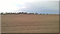
4
Ridged field off Chapel Lane, Ravenshead
Image: © Jonathan Thacker
Taken: 10 Mar 2020
0.24 miles