IMAGES TAKEN NEAR TO
Bishops Way, NOTTINGHAM, NG15 8DP
Introduction
This page details the photographs taken nearby to Bishops Way, NG15 8DP by members of the Geograph project.
The Geograph project started in 2005 with the aim of publishing, organising and preserving representative images for every square kilometre of Great Britain, Ireland and the Isle of Man.

There are currently over 7.5m images from over14,400 individuals and you can help contribute to the project by visiting https://www.geograph.org.uk
Image Map
Images are licensed for reuse under creativecommons.org/licenses/by-sa/2.0
Notes
- Clicking on the map will re-center to the selected point.
- The higher the marker number, the further away the image location is from the centre of the postcode.
Image Listing (10 Images Found)
Images are licensed for reuse under creativecommons.org/licenses/by-sa/2.0
Image
Details
Distance
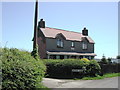
1
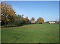
Park near Leen Mills Primary School, Hucknall
Image: © Tim Heaton
Taken: 11 Nov 2012
0.05 miles
2
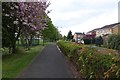
Cycle and foot path beside Bishop's Way
Part of NCN route 6.
Image: © David Lally
Taken: 27 Apr 2017
0.06 miles
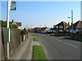
5
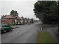
Papplewick Lane, Hucknall
the junction of Papplewick Lane, Leebrook Gardens and Buckingham Avenue
Image: © Tom Courtney
Taken: 13 Aug 2005
0.18 miles
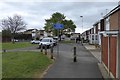
7
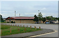
Hucknall Leisure Centre
The nearest building is the latest addition to the complex.
Image: © Alan Murray-Rust
Taken: 7 Jun 2010
0.22 miles
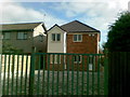
8
Hayden Villa, Linby
At the corner of Church Lane and Hayden Lane.
Image: © Dave Hitchborne
Taken: 12 Apr 2006
0.22 miles
9
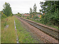
Mansfield-to-Nottingham Railway
Single track heading south at the outskirts of Hucknall.
Image: © Trevor Rickard
Taken: 18 Sep 2010
0.24 miles
10
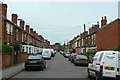
Co-operative Avenue
A typical terraced street in this primarily mining town.
Image: © Alan Murray-Rust
Taken: 7 Jun 2010
0.24 miles