IMAGES TAKEN NEAR TO
Gipsy Lane, NOTTINGHAM, NG15 8BD
Introduction
This page details the photographs taken nearby to Gipsy Lane, NG15 8BD by members of the Geograph project.
The Geograph project started in 2005 with the aim of publishing, organising and preserving representative images for every square kilometre of Great Britain, Ireland and the Isle of Man.

There are currently over 7.5m images from over14,400 individuals and you can help contribute to the project by visiting https://www.geograph.org.uk
Image Map
Images are licensed for reuse under creativecommons.org/licenses/by-sa/2.0
Notes
- Clicking on the map will re-center to the selected point.
- The higher the marker number, the further away the image location is from the centre of the postcode.
Image Listing (5 Images Found)
Images are licensed for reuse under creativecommons.org/licenses/by-sa/2.0
Image
Details
Distance
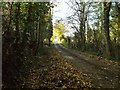
2

Track and Bridleway off Annesley Road
Heading in the direction of Thurland Hall Farm.
Image: © Jonathan Clitheroe
Taken: 9 Sep 2023
0.19 miles
3
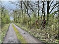
Track and Bridleway off Annesley Road
Pretty much the same shot as Image But the early spring lack of leaves means that a dumped lorry trailer in the adjoining field is visible.
Image: © David Lally
Taken: 3 Apr 2024
0.22 miles
4
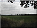
Farmland near Wighay Woods
taken from the Annesley By-pass
Image: © Tom Courtney
Taken: 15 Aug 2005
0.24 miles