IMAGES TAKEN NEAR TO
Wighay Road, NOTTINGHAM, NG15 8AH
Introduction
This page details the photographs taken nearby to Wighay Road, NG15 8AH by members of the Geograph project.
The Geograph project started in 2005 with the aim of publishing, organising and preserving representative images for every square kilometre of Great Britain, Ireland and the Isle of Man.

There are currently over 7.5m images from over14,400 individuals and you can help contribute to the project by visiting https://www.geograph.org.uk
Image Map
Images are licensed for reuse under creativecommons.org/licenses/by-sa/2.0
Notes
- Clicking on the map will re-center to the selected point.
- The higher the marker number, the further away the image location is from the centre of the postcode.
Image Listing (109 Images Found)
Images are licensed for reuse under creativecommons.org/licenses/by-sa/2.0
Image
Details
Distance
3
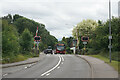
Level crossing on the B6011
The only remaining one of three railway lines which passed here between Linby and Wighay. The surviving line had to be reopened and is now the Robin Hood Line.
Image: © Bill Boaden
Taken: 2 Jul 2022
0.05 miles

5
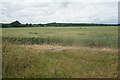
Wheat field near Wighay
Looking north from the B6011.
Image: © Bill Boaden
Taken: 2 Jul 2022
0.09 miles
6
Path to Linby
Heading north down the hill at The Ranges. Linby church tower on the right.
Image: © Trevor Rickard
Taken: 18 Sep 2010
0.09 miles
7
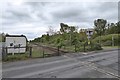
Main Street, Linby
South west of the Village is a Traffic Island and Level Crossing
Image: © Tom Courtney
Taken: 13 Aug 2005
0.11 miles
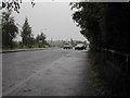
8
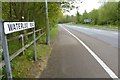
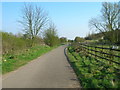
Waterloo Road
Forms part of the National Cycle Network Route 6.
Image: © David Lally
Taken: 27 Apr 2017
0.11 miles

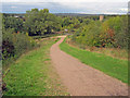
10
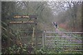
Linby Trail
At one time there were three separate railway lines that passed through the Leen Valley and there was enough coal traffic to keep all of them busy. This is a stretch of the former Great Northern Line which was the first to lose its passenger service, but survived as a freight only line until 1968. No coal is mined in this area now; the former Midland Railway route has been revived as the Robin Hood Line for passenger trains between Nottingham and Worksop, the Great Central Line has been more or less obliterated but this line has become the Linby Trail for walkers and cyclists.
Image: © Stephen McKay
Taken: 1 Jan 2012
0.12 miles