IMAGES TAKEN NEAR TO
Kneesall Grove, NOTTINGHAM, NG15 7UJ
Introduction
This page details the photographs taken nearby to Kneesall Grove, NG15 7UJ by members of the Geograph project.
The Geograph project started in 2005 with the aim of publishing, organising and preserving representative images for every square kilometre of Great Britain, Ireland and the Isle of Man.

There are currently over 7.5m images from over14,400 individuals and you can help contribute to the project by visiting https://www.geograph.org.uk
Image Map
Images are licensed for reuse under creativecommons.org/licenses/by-sa/2.0
Notes
- Clicking on the map will re-center to the selected point.
- The higher the marker number, the further away the image location is from the centre of the postcode.
Image Listing (168 Images Found)
Images are licensed for reuse under creativecommons.org/licenses/by-sa/2.0
Image
Details
Distance
1
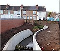
Wollaton Street Vicinity, Hucknall, Notts.
The works depot for the new 'town centre relief road' is visible ahead. The road was opened in November 2016. The overall scheme received final funding approval from the Department for Transport in February 2015 (procured using the Medium Scheme Framework 2, through the Midlands Highway Alliance). Carillion/Tarmac JV were awarded the contract and work started on site in January 2016. The work, including a pedestrianised section of High Street - between Baker Street and Watnall Road - is due to be completed in May 2017. The overall scheme aims to reduce traffic congestion, create an attractive shopping centre, attract new retailers and to assist in the regeneration of the town. The plans also incorporated flood relief measures, some of which are seen here. This stream, the Whyburn, has a total length of around 2.5 miles (4.0 km), and terminates in a confluence with the River Leen immediately upstream of Mill Lakes, Bestwood Village.
Image: © David Hallam-Jones
Taken: 17 Dec 2016
0.02 miles
2
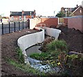
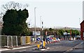
Wollaton Street Vicinity, Hucknall, Notts.
The pedestrian on the pavement parallel with the new 'town centre relief road' is walking towards its junction with Station Road. This road was opened in November 2016. The overall scheme received final funding approval from the Department for Transport in February 2015 (procured using the Medium Scheme Framework 2, through the Midlands Highway Alliance). Carillion/Tarmac JV were awarded the contract and work started on site in January 2016. The work, including a pedestrianised section of High Street - between Baker Street and Watnall Road - is due to be completed in May 2017. The overall scheme aims to reduce traffic congestion, create an attractive shopping centre, attract new retailers and to assist in the regeneration of the town. The plans also incorporated flood relief measures, part of which are seen here. This stream, the Whyburn, has a total length of around 2.5 miles (4.0 km), and terminates in a confluence with the River Leen immediately upstream of Mill Lakes, Bestwood Village.
Image: © David Hallam-Jones
Taken: 17 Dec 2016
0.02 miles
3
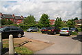
Carpark off Station Road
Wollaton Street behind.
Image: © Chris
Taken: 13 May 2014
0.03 miles
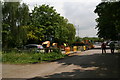
4
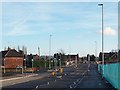
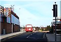
Albert Street Vicinity, Hucknall, Notts.
This 'town centre relief road' is a feature of Hucknall’s current town centre improvement scheme (TCIS). It was opened in November 2016. This is a view from its mid-point (approx) between the new Annesley Road mini-roundabout the Station Road/Ashgate Road area. Buses travelling towards Nottingham from the Wighay area of Hucknall now turn right near the car seen here in order to rejoin High Street. The overall improvement scheme received final funding approval from the Department for Transport in February 2015 (procured using the Medium Scheme Framework 2, through the Midlands Highway Alliance). Carillion/Tarmac JV were awarded the contract and work started on site in January 2016. The work, including a pedestrianised section of High Street between Baker Street and Watnall Road, is due to be completed in May 2017. The overall scheme aims to reduce traffic congestion, create an attractive shopping centre, attract new retailers and to assist in the regeneration of the town. Flood prevention measures are being strengthen simultaneously, as part of the project.
Image: © David Hallam-Jones
Taken: 17 Dec 2016
0.06 miles
5
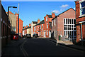
Woollaton Street
Runs northward off the High Street.
Image: © David Lally
Taken: 13 Mar 2010
0.07 miles
6
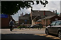
Shop backs on High Street
Viewed from carpark accessed from Station Road.
Image: © Chris
Taken: 13 May 2014
0.08 miles
7
Station Road Vicinity, Hucknall, Notts.
This is the Station Road/Ashgate Road end of the new, ‘town centre relief road’, a feature of Hucknall’s current town centre improvement scheme (TCIS). The railway station (4-5 mins away on foot) can be reached by turning left at this junction, whilst Portland Street - leading towards Nottingham - is reached via a right turn. This new road was opened in November 2016. The overall scheme received final funding approval from the Department for Transport in February 2015 (procured using the Medium Scheme Framework 2, through the Midlands Highway Alliance). Carillion/Tarmac JV were awarded the contract and work started on site in January 2016. The work, including a pedestrianised section of High Street - between Baker Street and Watnall Road - is due to be completed in May 2017. The overall scheme aims to reduce traffic congestion, create an attractive shopping centre, attract new retailers and to assist in the regeneration of the town.
Image: © David Hallam-Jones
Taken: 17 Dec 2016
0.08 miles
8
Bus Gate, High Street, Hucknall, Notts.
Now that vehicles can no longer be driven along the Watnall Lane-Baker Street section of High Street, a new "buses only" link road has been created to connect the Portland Road end of High Street with the recently completed relief road (ahead).
Image: © David Hallam-Jones
Taken: 17 Dec 2016
0.08 miles
10
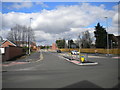
Inner relief road, Hucknall
A recent construction. This is the south eastern end of it, seen from Station Road.
Image: © Richard Vince
Taken: 2 Apr 2017
0.09 miles