IMAGES TAKEN NEAR TO
Oakenhall Avenue, NOTTINGHAM, NG15 7TE
Introduction
This page details the photographs taken nearby to Oakenhall Avenue, NG15 7TE by members of the Geograph project.
The Geograph project started in 2005 with the aim of publishing, organising and preserving representative images for every square kilometre of Great Britain, Ireland and the Isle of Man.

There are currently over 7.5m images from over14,400 individuals and you can help contribute to the project by visiting https://www.geograph.org.uk
Image Map
Images are licensed for reuse under creativecommons.org/licenses/by-sa/2.0
Notes
- Clicking on the map will re-center to the selected point.
- The higher the marker number, the further away the image location is from the centre of the postcode.
Image Listing (35 Images Found)
Images are licensed for reuse under creativecommons.org/licenses/by-sa/2.0
Image
Details
Distance
1
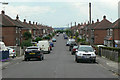
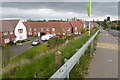
Oakenhall Avenue
A long cul-de-sac off Wigwam Lane surrounded by greenery.
Image: © Alan Murray-Rust
Taken: 7 Jun 2010
0.06 miles
2
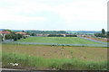
Playing fields
At the back of houses off Papplewick Lane.
Image: © Alan Murray-Rust
Taken: 7 Jun 2010
0.11 miles
3
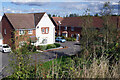
Olympia Way, Hucknall
Looking down from Wigwam Lane, the houses here were built in 2013. They are especially convenient for the town's railway station and tram stop.
Image: © Stephen McKay
Taken: 16 Sep 2022
0.14 miles
5
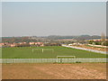
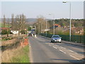
New Estate of houses beside Wigwam Lane
Route 6 of the National Cycle Network goes along here but at this point it's unclear as to whether one should be on the pavement (possibly allocated as a shared cycle path?) or the road.
Although this looks at this point like a major through route to somewhere Wigwam Lane is just for access to industrial units at Butler's Hill and is a no through road for motor vehicles.
Image: © David Lally
Taken: 27 Apr 2017
0.15 miles
7
Hucknall Golf Centre
Developed on the spoil tip of the former Hucknall No.2 Colliery.
Image: © Alan Murray-Rust
Taken: 7 Jun 2010
0.17 miles
8
Papplewick Lane in Hucknall
Situated at the western edge of this square close to the railway station.
Image: © Jonathan Clitheroe
Taken: 14 Jun 2022
0.18 miles
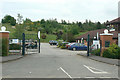
9
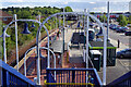
Hucknall Station and Tram Stop
This is a rather complicated scene showing Hucknall's one platform railway station opened in 1993 as a replacement for Hucknall Byron which closed almost 30 years earlier in 1964. To the right of that is the tram stop, a terminus on the NET network, first opened in 2004.
Image: © Stephen McKay
Taken: 16 Sep 2022
0.18 miles
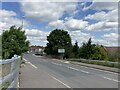
10
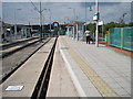
Hucknall (Byron) railway station, Nottinghamshire
Opened in 1848 by the Midland Railway on the line from Nottingham to Worksop, this station closed in 1964. It was reopened in 1993.
View north towards Linby and Worksop. Only one platform (far right, the former southbound platform) was being used by trains when this image was taken. The western, former northbound, side of the platform is used by trams.
Image: © Nigel Thompson
Taken: 13 May 2010
0.18 miles