IMAGES TAKEN NEAR TO
Hanson Crescent, NOTTINGHAM, NG15 7LF
Introduction
This page details the photographs taken nearby to Hanson Crescent, NG15 7LF by members of the Geograph project.
The Geograph project started in 2005 with the aim of publishing, organising and preserving representative images for every square kilometre of Great Britain, Ireland and the Isle of Man.

There are currently over 7.5m images from over14,400 individuals and you can help contribute to the project by visiting https://www.geograph.org.uk
Image Map
Images are licensed for reuse under creativecommons.org/licenses/by-sa/2.0
Notes
- Clicking on the map will re-center to the selected point.
- The higher the marker number, the further away the image location is from the centre of the postcode.
Image Listing (139 Images Found)
Images are licensed for reuse under creativecommons.org/licenses/by-sa/2.0
Image
Details
Distance
1
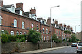
Colliery Houses
Built around 1875 by the colliery company for its workers. The distinctive use of red and black bricks is very much of its period.
Image: © Alan Murray-Rust
Taken: 7 Jun 2010
0.04 miles
2
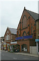
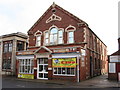
Victorian buildings on Watnall Road
The nearer building was probably a Wesleyan Methodist chapel - there are identifiable Baptist and Primitive Methodist churches just up the same street. Beyond is the former Public Hall of 1875 http://www.geograph.org.uk/photo/1906373 ; both are now converted to retail use.
Image: © Alan Murray-Rust
Taken: 7 Jun 2010
0.05 miles
3
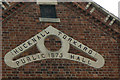
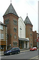
Hucknall Torkard Public Hall
A reminder that the proper full name of this town is Hucknall Torkard, although the second part has long fallen out of normal use. The hall dates from the time of the major expansion of the small market town into a thriving mining community.
Image: © Alan Murray-Rust
Taken: 7 Jun 2010
0.05 miles
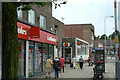
4
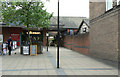
Shopping mall
A small modern mall off High Street. The Wilkinson store on the left portrays the recently introduced house style replacing the old 'Wilko' image.
Image: © Alan Murray-Rust
Taken: 7 Jun 2010
0.06 miles
6
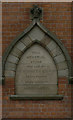
Check the date!
Memorial stone, Hucknall Baptist Church. Although a year date in roman numerals is common, the day date is less so.
Careful study shows that the mason got carried away when inscribing the year, and has turned the final I into an L. Taken literally, this would mean a date of 1875 plus 50 years.
Image: © Alan Murray-Rust
Taken: 7 Jun 2010
0.06 miles
7
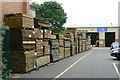
Timber yard
The firm, Geo Hanson Ltd., combines timber supply and joinery with activities as a funeral director.
Image: © Alan Murray-Rust
Taken: 7 Jun 2010
0.06 miles
8
Hucknall Baptist Church
A fine display of Victorian Gothic-inspired architecture, dating from MDCCCLXXVL according to the date stone http://www.geograph.org.uk/photo/1906378 . Presumably a mistake for 1876.
Image: © Alan Murray-Rust
Taken: 7 Jun 2010
0.07 miles
9
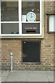
Posting box, Hucknall Post Office - Ref: NG15 1
This style of built-in posting box has become more uncommon since the Royal Mail was separated from the Post Office. Here the internal collection facilities have been replaced by an external door, but the original brass slot has survived.
Image: © Alan Murray-Rust
Taken: 7 Jun 2010
0.07 miles
10
Hucknall Post Office
1960s architecture on High Street.
Image: © Alan Murray-Rust
Taken: 7 Jun 2010
0.08 miles