IMAGES TAKEN NEAR TO
Watnall Road, NOTTINGHAM, NG15 7LB
Introduction
This page details the photographs taken nearby to Watnall Road, NG15 7LB by members of the Geograph project.
The Geograph project started in 2005 with the aim of publishing, organising and preserving representative images for every square kilometre of Great Britain, Ireland and the Isle of Man.

There are currently over 7.5m images from over14,400 individuals and you can help contribute to the project by visiting https://www.geograph.org.uk
Image Map
Images are licensed for reuse under creativecommons.org/licenses/by-sa/2.0
Notes
- Clicking on the map will re-center to the selected point.
- The higher the marker number, the further away the image location is from the centre of the postcode.
Image Listing (155 Images Found)
Images are licensed for reuse under creativecommons.org/licenses/by-sa/2.0
Image
Details
Distance
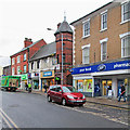
1
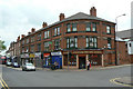
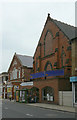
Victorian shops
On the corner of Portland Road and Watnall Road.
Image: © Alan Murray-Rust
Taken: 7 Jun 2010
0.01 miles
3
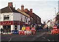
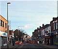
High Street, Hucknall, Notts.
As part of an on-going town centre improvement scheme (November 2016-May 2017), the Watnall Road to Baker Street section of High Street - i.e. from here to the Parish Church in the distance - is soon to be pedestrianised. An associated ‘town centre relief road’ to deal with the now-disrupted traffic has already been completed and was formally opened in November 2016. Pedestrians can reach the area through which the relief road passes by turning right at these traffic lights. Nottingham lies 4-5 miles behind the photographer.
Image: © David Hallam-Jones
Taken: 17 Dec 2016
0.02 miles
4
High Street, Hucknall
Looking north west from the corner of Woollaton Street.
Image: © David Lally
Taken: 13 Mar 2010
0.02 miles
5
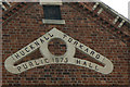
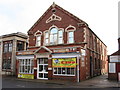
Hucknall Torkard Public Hall
A reminder that the proper full name of this town is Hucknall Torkard, although the second part has long fallen out of normal use. The hall dates from the time of the major expansion of the small market town into a thriving mining community.
Image: © Alan Murray-Rust
Taken: 7 Jun 2010
0.02 miles
6
Victorian buildings on Watnall Road
The nearer building was probably a Wesleyan Methodist chapel - there are identifiable Baptist and Primitive Methodist churches just up the same street. Beyond is the former Public Hall of 1875 http://www.geograph.org.uk/photo/1906373 ; both are now converted to retail use.
Image: © Alan Murray-Rust
Taken: 7 Jun 2010
0.03 miles
7
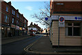
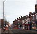
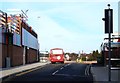
High St/Watnall Rd Junction, Hucknall, Notts.
As part of Hucknall's town centre improvement scheme (November 2016-May 2017), the Baker Street to Watnall Road section of High Street - i.e. from the Market Place, two minutes away behind the photographer, to the junction ahead - is soon to be pedestrianised. The red car in the picture is pulling out of Watnall Road, i.e. the B6009 and is heading in the general direction of Nottingham. An associated ‘town centre relief road’ to deal with the now-disrupted traffic has already been completed and was formally opened in November 2016. Pedestrians can reach the area through which the relief road passes by turning left at the traffic lights ahead.
Image: © David Hallam-Jones
Taken: 17 Dec 2016
0.03 miles
8
High St/Watnall Rd Junction, Hucknall, Notts.
As part of Hucknall's town centre improvement scheme (November 2016-May 2017), the Baker Street to Watnall Road section of High Street - i.e. from the Market Place behind the photographer to the junction ahead - is soon to be pedestrianised. An associated ‘town centre relief road’ has already been completed and was formally opened in November 2016.
Image: © David Hallam-Jones
Taken: 17 Dec 2016
0.04 miles
9
Hucknall High Street
The building in the centre, originally Hucknall Coffee Tavern and Institute, is a less well-known work of the celebrated Nottingham architect Watson Fothergill. For more about Fothergill, and pictures of most of his buildings, see http://www.geograph.org.uk/article/The-Buildings-of-Watson-Fothergill .
Image: © John Sutton
Taken: 7 Apr 2014
0.04 miles
10
Bus Gate, High Street, Hucknall, Notts.
Now that vehicles can no longer be driven along the Watnall Lane-Baker Street section of High Street, a new "buses only" link road has been created to connect the Portland Road end of High Street with the recently completed relief road (ahead).
Image: © David Hallam-Jones
Taken: 17 Dec 2016
0.04 miles