IMAGES TAKEN NEAR TO
Croft Avenue, NOTTINGHAM, NG15 7JB
Introduction
This page details the photographs taken nearby to Croft Avenue, NG15 7JB by members of the Geograph project.
The Geograph project started in 2005 with the aim of publishing, organising and preserving representative images for every square kilometre of Great Britain, Ireland and the Isle of Man.

There are currently over 7.5m images from over14,400 individuals and you can help contribute to the project by visiting https://www.geograph.org.uk
Image Map
Images are licensed for reuse under creativecommons.org/licenses/by-sa/2.0
Notes
- Clicking on the map will re-center to the selected point.
- The higher the marker number, the further away the image location is from the centre of the postcode.
Image Listing (29 Images Found)
Images are licensed for reuse under creativecommons.org/licenses/by-sa/2.0
Image
Details
Distance
2
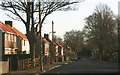
Hucknall, NG15 - Hazelgrove Area
A view of part of Titchfield Park - with Park Drive in the background - as seen from beneath the former boathouse structure that now serves as a shelter. The boathouse is an ornamental shelter that once stood on the banks of the park's boating lake. The boathouse was built in 1928 from funds given by the Hucknall Miners' Welfare Committee for improvements to the park. This shelter was restored in 2009 with a Lottery Fund grant.
Image: © David Hallam-Jones
Taken: 17 Nov 2012
0.10 miles
3
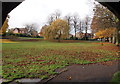
Hucknall, NG15 - Hazelgrove Area
The children's playground area of Titchfield Park was seen from beneath the former boathouse structure that now serves as a shelter from wet weather. The boathouse is an ornamental shelter that once stood on the banks of the park's boating lake. The boathouse was built in 1928 from funds given by the Hucknall Miners' Welfare Committee for improvements to the park and it was restored in 2009 with a Lottery Fund grant.
Image: © David Hallam-Jones
Taken: 17 Nov 2012
0.11 miles
4
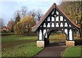
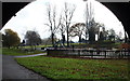
Hucknall, NG15 - Hazelgrove Area
This boathouse structure stood on the banks of the boating lake in the days when the park boasted a such a lake; a bandstand and tearooms. The boathouse was built in 1928 from funds provided by the Hucknall Miners Welfare Committee as part of an extension to the park. Now a shelter over one of its paths, the structure was restored in 2009 with the aid of a Lottery Fund grant.
Image: © David Hallam-Jones
Taken: 17 Nov 2012
0.13 miles
5
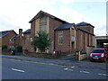
Holy Cross church, Hucknall
Dates from 1959.
Image: © Jonathan Thacker
Taken: 5 Nov 2023
0.16 miles
6
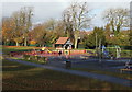
Hucknall, NG15 - Hazelgrove Area
The children's playground area of Titchfield Park. This park was created in 1914 when the Duke of Portland gave 11 acres of land to the town council in an area known as Caddow Park, to mark the 21st birthday of his son, The Marquis of Titchfield. A further 13 acres was added when the Hucknall Miners Welfare Committee decided to contribute to the development of Titchfield Park for the benefit of local miners. The extension work were held up by the outbreak of the First World War and it was not until 1922 that the Marquis finally performed the opening ceremony.
Image: © David Hallam-Jones
Taken: 17 Nov 2012
0.16 miles
7
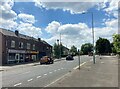
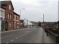
Row of Shops on Watnall Road, Hucklow
Image: © Jonathan Clitheroe
Taken: 14 Jun 2022
0.17 miles
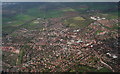
10
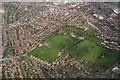
Hucknall: aerial 2014
Titchfield Park in the centre.
Image: © Chris
Taken: 9 Apr 2014
0.18 miles