IMAGES TAKEN NEAR TO
Sandy Lane, NOTTINGHAM, NG15 7GQ
Introduction
This page details the photographs taken nearby to Sandy Lane, NG15 7GQ by members of the Geograph project.
The Geograph project started in 2005 with the aim of publishing, organising and preserving representative images for every square kilometre of Great Britain, Ireland and the Isle of Man.

There are currently over 7.5m images from over14,400 individuals and you can help contribute to the project by visiting https://www.geograph.org.uk
Image Map
Images are licensed for reuse under creativecommons.org/licenses/by-sa/2.0
Notes
- Clicking on the map will re-center to the selected point.
- The higher the marker number, the further away the image location is from the centre of the postcode.
Image Listing (46 Images Found)
Images are licensed for reuse under creativecommons.org/licenses/by-sa/2.0
Image
Details
Distance
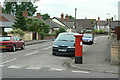
1
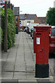
Sandy Lane postbox Ref No. NG15 6
Standard GR pillar box on the corner of Beech Avenue. Probably from the early years of the reign to judge from the surrounding architecture.
Image: © Alan Murray-Rust
Taken: 7 Jun 2010
0.03 miles
2
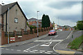
Gardeners Close
New housing off Sandy Lane.
Image: © Alan Murray-Rust
Taken: 7 Jun 2010
0.03 miles
3
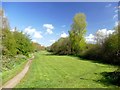
Former railway
This green space is on the former Great Central Railway line to the west of Hucknall.
Image: © Graham Hogg
Taken: 3 May 2016
0.08 miles
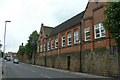
4
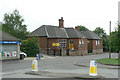
Oceans Day Nursery
Formerly Spring Street School
Image: © Alan Murray-Rust
Taken: 7 Jun 2010
0.09 miles
5
Former Spring Street School
Now a kickboxing centre.
Image: © Alan Murray-Rust
Taken: 7 Jun 2010
0.12 miles
6
Derbyshire Lane postbox Ref: NG15 5
GR standard pillar box on the corner of William Street into which we are looking.
Image: © Alan Murray-Rust
Taken: 7 Jun 2010
0.14 miles
7
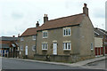
Stone Cottage
An old cottage which almost certainly pre-dates the growth of Hucknall as an industrial town.
Image: © Alan Murray-Rust
Taken: 7 Jun 2010
0.14 miles
8
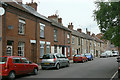
West Terrace
An interesting mixture of architectural styles showing that the street was developed piecemeal. One of the earliest developments for colliery workers, probably dating from the 1870s.
Image: © Alan Murray-Rust
Taken: 7 Jun 2010
0.14 miles
9
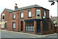
Former grocer's shop
On the corner of West Street and West Terrace. Still showing the signs of the old Home Ales brewery of Nottingham which closed in 1996.
Image: © Alan Murray-Rust
Taken: 7 Jun 2010
0.16 miles
10
Development at the junction of Spring Street and Ogle Street
The redevelopment of Darlison Court is part of the Ashfield District Council plan to build its first new council properties for nearly 30 years. It will provide new sustainable housing for retired people.
Image: © Chris
Taken: 11 Oct 2015
0.17 miles