IMAGES TAKEN NEAR TO
Heyworth Road, NOTTINGHAM, NG15 6XJ
Introduction
This page details the photographs taken nearby to Heyworth Road, NG15 6XJ by members of the Geograph project.
The Geograph project started in 2005 with the aim of publishing, organising and preserving representative images for every square kilometre of Great Britain, Ireland and the Isle of Man.

There are currently over 7.5m images from over14,400 individuals and you can help contribute to the project by visiting https://www.geograph.org.uk
Image Map
Images are licensed for reuse under creativecommons.org/licenses/by-sa/2.0
Notes
- Clicking on the map will re-center to the selected point.
- The higher the marker number, the further away the image location is from the centre of the postcode.
Image Listing (12 Images Found)
Images are licensed for reuse under creativecommons.org/licenses/by-sa/2.0
Image
Details
Distance
1
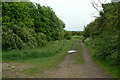
Footpath off Daniels Way
A bridleway up to this point, but just a footpath from here on.
Image: © Alan Murray-Rust
Taken: 7 Jun 2010
0.13 miles
2
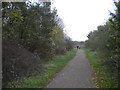
Track towards Bulwell Hall from Westville
Image: © Richard Vince
Taken: 28 Oct 2017
0.13 miles
3
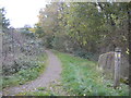
Public footpath to Hucknall near Westville
Heading towards Hucknall town centre via Hazelgrove.
Image: © Richard Vince
Taken: 28 Oct 2017
0.15 miles
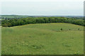
4
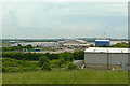
View from the tip
The former spoil tip of Hucknall No.1 colliery has been landscaped and provides a vantage point to look over the Rolls Royce testing centre at Hucknall airfield.
Image: © Alan Murray-Rust
Taken: 7 Jun 2010
0.18 miles
5
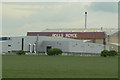
Rolls Royce
The Hucknall Airfield site seen from Farleys Lane.
Image: © Alan Murray-Rust
Taken: 7 Jun 2010
0.20 miles
6

Buttercups and clover
Flower meadow has clearly been left to flourish on the former spoil tip of Hucknall No.1 Colliery. This is part of the field seen in http://www.geograph.org.uk/photo/1907393.
Image: © Alan Murray-Rust
Taken: 7 Jun 2010
0.20 miles
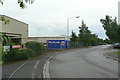
7
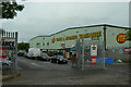
DIY supplies
A large trade warehouse on Daniels Way.
Image: © Alan Murray-Rust
Taken: 7 Jun 2010
0.22 miles
8
View along the tip
All the ground in the foreground, including the woodland, is the regenerated spoil tip of the former Hucknall No.1 colliery.
Image: © Alan Murray-Rust
Taken: 7 Jun 2010
0.22 miles
9
Road off Daniels Way, Westville
Providing access to some industrial units; also host to a public bridleway, which continues beyond the industrial estate as a track,
Image: © Richard Vince
Taken: 28 Oct 2017
0.23 miles
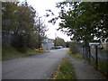
10
Daniels Way
Industrial development on the northern side of Hucknall Airfield.
Image: © Alan Murray-Rust
Taken: 7 Jun 2010
0.23 miles