IMAGES TAKEN NEAR TO
Lovesey Avenue, NOTTINGHAM, NG15 6XA
Introduction
This page details the photographs taken nearby to Lovesey Avenue, NG15 6XA by members of the Geograph project.
The Geograph project started in 2005 with the aim of publishing, organising and preserving representative images for every square kilometre of Great Britain, Ireland and the Isle of Man.

There are currently over 7.5m images from over14,400 individuals and you can help contribute to the project by visiting https://www.geograph.org.uk
Image Map
Images are licensed for reuse under creativecommons.org/licenses/by-sa/2.0
Notes
- Clicking on the map will re-center to the selected point.
- The higher the marker number, the further away the image location is from the centre of the postcode.
Image Listing (5 Images Found)
Images are licensed for reuse under creativecommons.org/licenses/by-sa/2.0
Image
Details
Distance
1
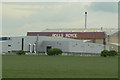
Rolls Royce
The Hucknall Airfield site seen from Farleys Lane.
Image: © Alan Murray-Rust
Taken: 7 Jun 2010
0.16 miles
2
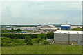
View from the tip
The former spoil tip of Hucknall No.1 colliery has been landscaped and provides a vantage point to look over the Rolls Royce testing centre at Hucknall airfield.
Image: © Alan Murray-Rust
Taken: 7 Jun 2010
0.19 miles
3
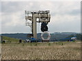
Rolls Royce engine test bed, Hucknall
Situated at the former RAF Hucknall airfield this test rig is situated midway along the disused tarmac runway and is well shielded by man-made grass banks to protect the local populace from noise. The airfield is still used by the local flying club at weekends using adjacent grass runways.
Image: © Tony Wheeler
Taken: 23 Jun 2007
0.19 miles
4
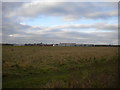
Merlin Park, Hucknall
Merlin Park is a Land Trust development on the site of the former Hucknall airfield. As well as housing (seen distantly here) and industry, a large area of the former airfield has been retained as calcareous grassland which is an ecologically important habitat within the local area.
Image: © Alan Murray-Rust
Taken: 19 Jul 2022
0.22 miles
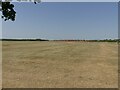
5
Hucknall Aerodrome from Bulwell Hall Park
The view of the aerodrome from a public footpath, part of the Robin Hood Way, that passes along the western edge of Bulwell Hall Park. The buildings in the centre belong to Rolls-Royce, and are, if memory serves, used for testing aero engines.
Image: © Richard Vince
Taken: 16 Nov 2013
0.24 miles