IMAGES TAKEN NEAR TO
Canberra Crescent, NOTTINGHAM, NG15 6WH
Introduction
This page details the photographs taken nearby to Canberra Crescent, NG15 6WH by members of the Geograph project.
The Geograph project started in 2005 with the aim of publishing, organising and preserving representative images for every square kilometre of Great Britain, Ireland and the Isle of Man.

There are currently over 7.5m images from over14,400 individuals and you can help contribute to the project by visiting https://www.geograph.org.uk
Image Map
Images are licensed for reuse under creativecommons.org/licenses/by-sa/2.0
Notes
- Clicking on the map will re-center to the selected point.
- The higher the marker number, the further away the image location is from the centre of the postcode.
Image Listing (14 Images Found)
Images are licensed for reuse under creativecommons.org/licenses/by-sa/2.0
Image
Details
Distance
1
![Recent roundabout [2]](https://s3.geograph.org.uk/geophotos/05/34/08/5340819_be7fec99_120x120.jpg)
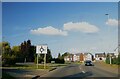
Recent roundabout [2]
This area is the scene of much development with new housing on the site of the old airfield. The roundabout is a recent addition to Watnall Road, B6009. See also Image
Image: © Michael Dibb
Taken: 30 Mar 2017
0.07 miles
2
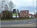
New housing
This area is the scene of much development with new housing on the site of the old airfield. The new estate is Hawkers Place and the cramped layout is in stark contrast to Olympus Court nearby Image
Image: © Michael Dibb
Taken: 30 Mar 2017
0.08 miles
3
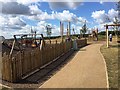
Rolls Royce Airfield Redevelopment
Children's play area near new housing on former part of Rolls Royce Airfield.
Image: © John Stolarski
Taken: 31 Jul 2018
0.13 miles
4
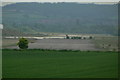
Runway at Hucknall
Once used by Rolls Royce for testing, the main runway is now out of use. The local flying club maintains two grass runways to the right of the far end of the
main surfaced runway.
Image: © Alan Murray-Rust
Taken: 21 May 2010
0.16 miles
5
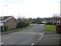
Olympus Court
A pleasant road of bungalows. The spacious layout is in stark contrast to the new housing being built on the site of the old airfield. Image
Image: © Michael Dibb
Taken: 30 Mar 2017
0.16 miles
7
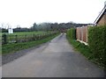
Driveway to the farm
From Watnall Road, B6009, the drive leads to Stubbing Wood Farm.
Image: © Michael Dibb
Taken: 30 Mar 2017
0.17 miles
8
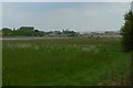
Hucknall Airfield
The runway is no longer used. The distant buildings are part of the Rolls Royce testing facility. The original 'Flying Bedsteads' which made use of vertical thrust jets later developed in the successful Harrier jump jet was tested here. http://en.wikipedia.org/wiki/Rolls-Royce_Thrust_Measuring_Rig
Image: © Alan Murray-Rust
Taken: 21 May 2010
0.18 miles
9
![Recent roundabout [1]](https://s0.geograph.org.uk/geophotos/05/34/08/5340800_8303b511_120x120.jpg)
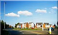
Recent roundabout [1]
This area is the scene of much development with new housing on the site of the old airfield. The roundabout is a recent addition to Watnall Road, B6009. See also Image
Image: © Michael Dibb
Taken: 30 Mar 2017
0.19 miles
10
Roundabout on Watnall Road (B6009), Hucknall
Image: © JThomas
Taken: 23 Sep 2023
0.19 miles