IMAGES TAKEN NEAR TO
Windermere Road, NOTTINGHAM, NG15 6NF
Introduction
This page details the photographs taken nearby to Windermere Road, NG15 6NF by members of the Geograph project.
The Geograph project started in 2005 with the aim of publishing, organising and preserving representative images for every square kilometre of Great Britain, Ireland and the Isle of Man.

There are currently over 7.5m images from over14,400 individuals and you can help contribute to the project by visiting https://www.geograph.org.uk
Image Map
Images are licensed for reuse under creativecommons.org/licenses/by-sa/2.0
Notes
- Clicking on the map will re-center to the selected point.
- The higher the marker number, the further away the image location is from the centre of the postcode.
Image Listing (19 Images Found)
Images are licensed for reuse under creativecommons.org/licenses/by-sa/2.0
Image
Details
Distance
1
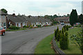
Coniston Road
Post war suburban development on the west side of Hucknall. The tower of the parish church is visible in the distance.
Image: © Alan Murray-Rust
Taken: 7 Jun 2010
0.09 miles
2
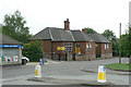
Oceans Day Nursery
Formerly Spring Street School
Image: © Alan Murray-Rust
Taken: 7 Jun 2010
0.13 miles
3
Gardeners Close
New housing off Sandy Lane.
Image: © Alan Murray-Rust
Taken: 7 Jun 2010
0.13 miles
4
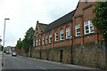
Former Spring Street School
Now a kickboxing centre.
Image: © Alan Murray-Rust
Taken: 7 Jun 2010
0.13 miles
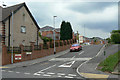
5
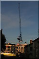
Development at the junction of Spring Street and Ogle Street
The redevelopment of Darlison Court is part of the Ashfield District Council plan to build its first new council properties for nearly 30 years. It will provide new sustainable housing for retired people.
Image: © Chris
Taken: 11 Oct 2015
0.14 miles
6
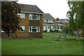
Darlison Court
A development of elderly persons' residences on Spring Street.
Image: © Alan Murray-Rust
Taken: 7 Jun 2010
0.14 miles
7
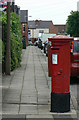
Sandy Lane postbox Ref No. NG15 6
Standard GR pillar box on the corner of Beech Avenue. Probably from the early years of the reign to judge from the surrounding architecture.
Image: © Alan Murray-Rust
Taken: 7 Jun 2010
0.15 miles
8
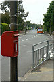
Wood Lane postbox Ref No NG15 13
An EIIR lamp box attached to a traditional wooden telegraph pole.
Image: © Alan Murray-Rust
Taken: 7 Jun 2010
0.16 miles
9
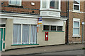
Annesley Road Post Office postbox Ref NG15 2
The siting of this wall box immediately suggests that there was once a post office here, although certainly no longer. The official name for the box confirms this.
Image: © Alan Murray-Rust
Taken: 7 Jun 2010
0.16 miles
10
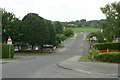
Greenwood Avenue
Looking from Coniston Road towards Washdyke Lane.
Image: © Alan Murray-Rust
Taken: 7 Jun 2010
0.17 miles