IMAGES TAKEN NEAR TO
Greenwood Vale, NOTTINGHAM, NG15 6LY
Introduction
This page details the photographs taken nearby to Greenwood Vale, NG15 6LY by members of the Geograph project.
The Geograph project started in 2005 with the aim of publishing, organising and preserving representative images for every square kilometre of Great Britain, Ireland and the Isle of Man.

There are currently over 7.5m images from over14,400 individuals and you can help contribute to the project by visiting https://www.geograph.org.uk
Image Map
Images are licensed for reuse under creativecommons.org/licenses/by-sa/2.0
Notes
- Clicking on the map will re-center to the selected point.
- The higher the marker number, the further away the image location is from the centre of the postcode.
Image Listing (6 Images Found)
Images are licensed for reuse under creativecommons.org/licenses/by-sa/2.0
Image
Details
Distance
1
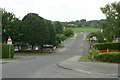
Greenwood Avenue
Looking from Coniston Road towards Washdyke Lane.
Image: © Alan Murray-Rust
Taken: 7 Jun 2010
0.08 miles
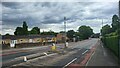
2
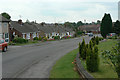
Coniston Road
Post war suburban development on the west side of Hucknall. The tower of the parish church is visible in the distance.
Image: © Alan Murray-Rust
Taken: 7 Jun 2010
0.14 miles
3
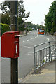
Wood Lane postbox Ref No NG15 13
An EIIR lamp box attached to a traditional wooden telegraph pole.
Image: © Alan Murray-Rust
Taken: 7 Jun 2010
0.20 miles
4
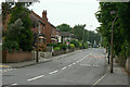
Wood Lane
Looking west from St Patrick's Road. This is the main route out to the western estates of Hucknall. The houses to the left are dated 1913 and 1914, the second one being named Mons Villas.
Image: © Alan Murray-Rust
Taken: 7 Jun 2010
0.22 miles
5
Annesley Road towards Hucknall town centre
Image: © James Emmans
Taken: 14 Jul 2022
0.24 miles
6
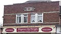
Art Deco detail
On an Annesley Road shop front. From around 1938 I'd say.
Image: © David Lally
Taken: 27 Apr 2017
0.25 miles