IMAGES TAKEN NEAR TO
Brixham Road, NOTTINGHAM, NG15 6JQ
Introduction
This page details the photographs taken nearby to Brixham Road, NG15 6JQ by members of the Geograph project.
The Geograph project started in 2005 with the aim of publishing, organising and preserving representative images for every square kilometre of Great Britain, Ireland and the Isle of Man.

There are currently over 7.5m images from over14,400 individuals and you can help contribute to the project by visiting https://www.geograph.org.uk
Image Map
Images are licensed for reuse under creativecommons.org/licenses/by-sa/2.0
Notes
- Clicking on the map will re-center to the selected point.
- The higher the marker number, the further away the image location is from the centre of the postcode.
Image Listing (5 Images Found)
Images are licensed for reuse under creativecommons.org/licenses/by-sa/2.0
Image
Details
Distance
1
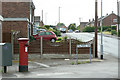
Polperro Way postbox Ref No. NG15 43
There are two boxes with Polperro Way as the official designation. This is at the north end of the road at the junction with Nabbs Lane.
Image: © Alan Murray-Rust
Taken: 7 Jun 2010
0.17 miles
2
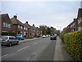
Rushcliffe Road, Ruffs estate
Seen from Nabbs Lane.
Image: © Richard Vince
Taken: 28 Oct 2017
0.22 miles
3
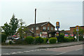
The Nabb Inn
This takes its name from the old name for this area, which means a piece of rising ground. It is still displaying the Hardy and Hanson signs although this is being phased out by the current owners, Greene King.
Image: © Alan Murray-Rust
Taken: 7 Jun 2010
0.22 miles
4
The Nabb Inn
This takes its name from the old name for this area, which means a piece of rising ground.
Image: © Alan Murray-Rust
Taken: 7 Jun 2010
0.23 miles
5
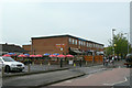
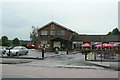
Shops on Nabbs Lane
Local shopping precinct serving the western part of the large housing development to the southwest of Hucknall.
Image: © Alan Murray-Rust
Taken: 7 Jun 2010
0.25 miles