IMAGES TAKEN NEAR TO
Westville Drive, NOTTINGHAM, NG15 6GQ
Introduction
This page details the photographs taken nearby to Westville Drive, NG15 6GQ by members of the Geograph project.
The Geograph project started in 2005 with the aim of publishing, organising and preserving representative images for every square kilometre of Great Britain, Ireland and the Isle of Man.

There are currently over 7.5m images from over14,400 individuals and you can help contribute to the project by visiting https://www.geograph.org.uk
Image Map
Images are licensed for reuse under creativecommons.org/licenses/by-sa/2.0
Notes
- Clicking on the map will re-center to the selected point.
- The higher the marker number, the further away the image location is from the centre of the postcode.
Image Listing (5 Images Found)
Images are licensed for reuse under creativecommons.org/licenses/by-sa/2.0
Image
Details
Distance
1
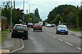
Watnall Road
The B6009 from Hucknall towards Watnall and Eastwood
Image: © Alan Murray-Rust
Taken: 7 Jun 2010
0.19 miles
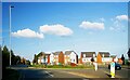
2
![Recent roundabout [1]](https://s0.geograph.org.uk/geophotos/05/34/08/5340800_8303b511_120x120.jpg)
Recent roundabout [1]
This area is the scene of much development with new housing on the site of the old airfield. The roundabout is a recent addition to Watnall Road, B6009. See also Image
Image: © Michael Dibb
Taken: 30 Mar 2017
0.23 miles
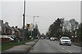
3
Roundabout on Watnall Road (B6009), Hucknall
Image: © JThomas
Taken: 23 Sep 2023
0.23 miles
4
Watching you watching me: speed camera, B6009, Hucknall
Image: © Chris
Taken: 26 Dec 2014
0.23 miles
5
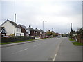
Watnall Road, Westville
The B6009 heading out of Hucknall.
Image: © Richard Vince
Taken: 28 Oct 2017
0.25 miles