IMAGES TAKEN NEAR TO
Kingsway Gardens, NOTTINGHAM, NG15 6FZ
Introduction
This page details the photographs taken nearby to Kingsway Gardens, NG15 6FZ by members of the Geograph project.
The Geograph project started in 2005 with the aim of publishing, organising and preserving representative images for every square kilometre of Great Britain, Ireland and the Isle of Man.

There are currently over 7.5m images from over14,400 individuals and you can help contribute to the project by visiting https://www.geograph.org.uk
Image Map
Images are licensed for reuse under creativecommons.org/licenses/by-sa/2.0
Notes
- Clicking on the map will re-center to the selected point.
- The higher the marker number, the further away the image location is from the centre of the postcode.
Image Listing (13 Images Found)
Images are licensed for reuse under creativecommons.org/licenses/by-sa/2.0
Image
Details
Distance
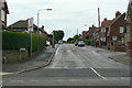
1
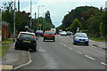
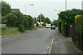
Watnall Road
The B6009 from Hucknall towards Watnall and Eastwood
Image: © Alan Murray-Rust
Taken: 7 Jun 2010
0.12 miles
2
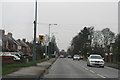
Watching you watching me: speed camera, B6009, Hucknall
Image: © Chris
Taken: 26 Dec 2014
0.13 miles
3
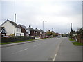
Watnall Road, Westville
The B6009 heading out of Hucknall.
Image: © Richard Vince
Taken: 28 Oct 2017
0.15 miles
5
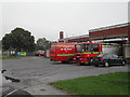
Hucknall Fire and Rescue Station
on Watnall Road
Image: © Tom Courtney
Taken: 5 Sep 2005
0.17 miles
6
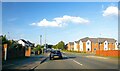
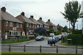
Ruffs Drive
The way into the main part of the Ruffs Estate off Watnall Road.
Image: © Alan Murray-Rust
Taken: 7 Jun 2010
0.19 miles
7
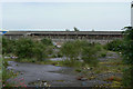
Industrial dereliction
Former industrial site alongside Watnall Road.
Image: © Alan Murray-Rust
Taken: 7 Jun 2010
0.21 miles
8
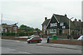
Masons Arms
Pub on Watnall Road built as part of the Ruffs Estate development in the post war period.
Image: © Alan Murray-Rust
Taken: 7 Jun 2010
0.21 miles
9
Daniels Way
Industrial development on the northern side of Hucknall Airfield. This road follows the route of an older lane, and is still classified as a bridleway.
Image: © Alan Murray-Rust
Taken: 7 Jun 2010
0.23 miles
10
Godber Road
Part of the Ruffs Estate, looking south from Nabbs Lane.
Image: © Alan Murray-Rust
Taken: 7 Jun 2010
0.23 miles