IMAGES TAKEN NEAR TO
Acacia Close, NOTTINGHAM, NG15 6BG
Introduction
This page details the photographs taken nearby to Acacia Close, NG15 6BG by members of the Geograph project.
The Geograph project started in 2005 with the aim of publishing, organising and preserving representative images for every square kilometre of Great Britain, Ireland and the Isle of Man.

There are currently over 7.5m images from over14,400 individuals and you can help contribute to the project by visiting https://www.geograph.org.uk
Image Map
Images are licensed for reuse under creativecommons.org/licenses/by-sa/2.0
Notes
- Clicking on the map will re-center to the selected point.
- The higher the marker number, the further away the image location is from the centre of the postcode.
Image Listing (18 Images Found)
Images are licensed for reuse under creativecommons.org/licenses/by-sa/2.0
Image
Details
Distance
1
Hucknall, NG15 - Butler's Hill Area
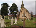
With the graveyard of Hucknall Torkard Parish Church beginning to fill up a Burial Board was elected in 1884 to find a suitable plot of land upon which to construct a cemetery. Such a spot was found in this locality known as the Moss Leys and eight acres was bought from the Duke of Portland in 1884 at £250 per acre. This is cemetery chapel, still in use, that was built by a Mr. J.A. Munks for £1,031. The houses in the background are situated in Brookside (street name) and the Hazelgrove area lies behind the photographer.
Image: © David Hallam-Jones
Taken: 17 Nov 2012
0.09 miles
2
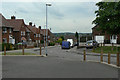
Johnson Avenue
1950s/60s housing in the south-eastern sector of the town.
Image: © Alan Murray-Rust
Taken: 7 Jun 2010
0.11 miles
3
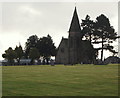
Hucknall, NG15 - Butler's Hill Area
Broomhill Junior School, Broomhill Road, is visible on the right of this chapel in the grounds of Hucknall Cemetery. This section of the cemetery appears hardly to have been used yet. This picture was taken with Brookside (i.e. a street name) behind the photographer.
Image: © David Hallam-Jones
Taken: 17 Nov 2012
0.11 miles
4
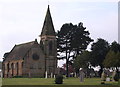
Hucknall, NG15 - Cemetery
With the graveyard of Hucknall Torkard Parish Church beginning to fill up a Burial Board was elected in 1884 to find a suitable plot of land upon which to construct a cemetery. Such a spot was found in this locality known as the Moss Leys and eight acres was bought from the Duke of Portland in 1884 at £250 per acre. This is cemetery chapel, that is still in use, that was built by Mr. J. A. Munks for £1,031.
Image: © David Hallam-Jones
Taken: 17 Nov 2012
0.12 miles
5
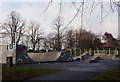
Hucknall, NG15 - Hazelgrove Area
The new £100,000 skateboard and BMX skate pistes in Titchfield Park that were opened in October 2011.
Image: © David Hallam-Jones
Taken: 17 Nov 2012
0.13 miles
6
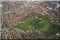
Hucknall: aerial 2014
Titchfield Park in the centre.
Image: © Chris
Taken: 9 Apr 2014
0.13 miles
7
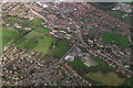
Hucknall: aerial 2014
Titchfield Park left, Butler's Hill top right.
Image: © Chris
Taken: 9 Apr 2014
0.13 miles
8
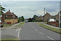
Broomhill Road
1950s/60s housing in the south-eastern sector of the town.
Image: © Alan Murray-Rust
Taken: 7 Jun 2010
0.14 miles
9
Torkard Park
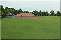
The southern end of Hucknall's main public park; this area is laid out with football pitches during the winter.
Image: © Alan Murray-Rust
Taken: 7 Jun 2010
0.15 miles
10
Hucknall, NG15 - Hazelgrove Area
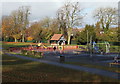
The children's playground area of Titchfield Park. This park was created in 1914 when the Duke of Portland gave 11 acres of land to the town council in an area known as Caddow Park, to mark the 21st birthday of his son, The Marquis of Titchfield. A further 13 acres was added when the Hucknall Miners Welfare Committee decided to contribute to the development of Titchfield Park for the benefit of local miners. The extension work were held up by the outbreak of the First World War and it was not until 1922 that the Marquis finally performed the opening ceremony.
Image: © David Hallam-Jones
Taken: 17 Nov 2012
0.16 miles