IMAGES TAKEN NEAR TO
Magnolia Grove, NOTTINGHAM, NG15 6AX
Introduction
This page details the photographs taken nearby to Magnolia Grove, NG15 6AX by members of the Geograph project.
The Geograph project started in 2005 with the aim of publishing, organising and preserving representative images for every square kilometre of Great Britain, Ireland and the Isle of Man.

There are currently over 7.5m images from over14,400 individuals and you can help contribute to the project by visiting https://www.geograph.org.uk
Image Map
Images are licensed for reuse under creativecommons.org/licenses/by-sa/2.0
Notes
- Clicking on the map will re-center to the selected point.
- The higher the marker number, the further away the image location is from the centre of the postcode.
Image Listing (6 Images Found)
Images are licensed for reuse under creativecommons.org/licenses/by-sa/2.0
Image
Details
Distance
1
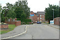
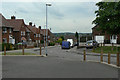
Rosemoor
New housing development at the south end of Farleys lane.
Image: © Alan Murray-Rust
Taken: 7 Jun 2010
0.19 miles
2
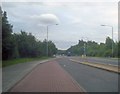
Lay-by on the A611
Looking south-east along the Hucknall bypass. Large lay-by with parking place and its own run-through lane.
Image: © Trevor Rickard
Taken: 31 Jul 2009
0.21 miles
3
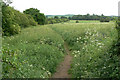
Footpath through the meadow
Not a recognised right of way, but aerial photos show quite a network of paths in this and the adjoining fields.
Image: © Alan Murray-Rust
Taken: 7 Jun 2010
0.22 miles
4
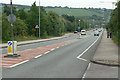
Hucknall Bypass
Looking southeast from Farleys Lane.
Image: © Alan Murray-Rust
Taken: 7 Jun 2010
0.23 miles
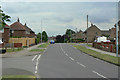
5
Johnson Avenue
1950s/60s housing in the south-eastern sector of the town.
Image: © Alan Murray-Rust
Taken: 7 Jun 2010
0.24 miles
6
Broomhill Road
1950s/60s housing in the south-eastern sector of the town.
Image: © Alan Murray-Rust
Taken: 7 Jun 2010
0.24 miles