IMAGES TAKEN NEAR TO
Stewart Way, NOTTINGHAM, NG15 0EH
Introduction
This page details the photographs taken nearby to Stewart Way, NG15 0EH by members of the Geograph project.
The Geograph project started in 2005 with the aim of publishing, organising and preserving representative images for every square kilometre of Great Britain, Ireland and the Isle of Man.

There are currently over 7.5m images from over14,400 individuals and you can help contribute to the project by visiting https://www.geograph.org.uk
Image Map
Images are licensed for reuse under creativecommons.org/licenses/by-sa/2.0
Notes
- Clicking on the map will re-center to the selected point.
- The higher the marker number, the further away the image location is from the centre of the postcode.
Image Listing (52 Images Found)
Images are licensed for reuse under creativecommons.org/licenses/by-sa/2.0
Image
Details
Distance
1
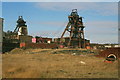
Annesley - Pit Head
The "A" pithead is on the left, with the "B" pithead on the right.
Image: © Dave Bevis
Taken: 1 Mar 2000
0.04 miles
2
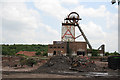
Annesley Headframe
Having survived as all around gradually disappeared, this headframe is currently threatened with demolition as the site is being developed for housing.
Image: © Alan Murray-Rust
Taken: 5 Jun 2008
0.05 miles
3
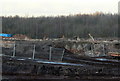
The last remains
These stumps of steelwork are all that remains of the remaining headframe of the former Annesley Colliery. Although it could have remained as a witness to what was the major industry in the area, the developer was much more interested in being able to get a couple or so more houses onto the site, and efforts to save it were unavailing.
Image: © Alan Murray-Rust
Taken: 31 Jan 2010
0.05 miles
4
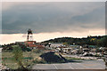
Annesley Colliery
The surviving headframe looks increasingly desolate in a waste of demolition.
Image: © Alan Murray-Rust
Taken: 17 Sep 2004
0.08 miles
5
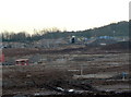
Remains of Annesley Colliery
Development is under way which will remove all signs that a large colliery existed on this site up to the 1990s.
Image: © Alan Murray-Rust
Taken: 31 Jan 2010
0.11 miles
6

Sad remains Annesley Pithead
The site is slowly being turned into an industrial estate
Image: © Tom Courtney
Taken: 15 Aug 2005
0.12 miles
7

Foot and cycle path
Between Newstead Village and the Hazelford Way Industrial Estate.
Image: © David Lally
Taken: 3 Apr 2024
0.12 miles
8
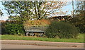
Pit memorabilia gracing the entrance of an industrial estate at Newstead
Image: © Chris
Taken: 1 Nov 2014
0.12 miles
9
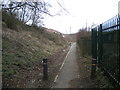
Footpath to the industrial estate, Newstead (1)
From the service road behind Chapel Terrace.
Image: © Richard Vince
Taken: 7 Mar 2020
0.12 miles
10
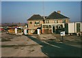
Annesley Colliery
Union Offices, formerly the Colliery Manager's house. Warren Hills in the background.
Image: © GARY ROE
Taken: 1 Feb 1994
0.13 miles