IMAGES TAKEN NEAR TO
Annesley, NOTTINGHAM, NG15 0AD
Introduction
This page details the photographs taken nearby to NG15 0AD by members of the Geograph project.
The Geograph project started in 2005 with the aim of publishing, organising and preserving representative images for every square kilometre of Great Britain, Ireland and the Isle of Man.

There are currently over 7.5m images from over14,400 individuals and you can help contribute to the project by visiting https://www.geograph.org.uk
Image Map
Images are licensed for reuse under creativecommons.org/licenses/by-sa/2.0
Notes
- Clicking on the map will re-center to the selected point.
- The higher the marker number, the further away the image location is from the centre of the postcode.
Image Listing (19 Images Found)
Images are licensed for reuse under creativecommons.org/licenses/by-sa/2.0
Image
Details
Distance
1
Riding stables near Annesley
View south to the buildings near the railway.
Image: © Trevor Rickard
Taken: 6 Feb 2010
0.01 miles
2

View from Robin Hood's Hills
Warren House Livery Stables are in the centre, with the Robin Hood Line just to the right. Annesley Village is just visible on the far right of the photo.
Image: © Antony Dixon
Taken: 27 Jul 2016
0.01 miles
3
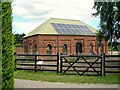
Former railway building
I am just guessing from the architectural style that that's what it is. Now in use as some kind of workshop or farm building.
Image: © Antony Dixon
Taken: 27 Jul 2016
0.02 miles
4
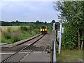
Robin Hood Line, Newstead
The Robin Hood Line runs from Nottingham to Worksop. This pic was taken just after the train has exited the Robin Hood tunnel at The Warren near Newstead.
Image: © Phil Evans
Taken: 24 Jul 2008
0.02 miles
5
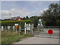
Level Crossing, Annesley Village
these are just north of the village on a farm track
Image: © Tom Courtney
Taken: 15 Aug 2005
0.04 miles
6
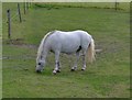
Little Grazing Pony, Newstead
My mum told me not to look up for photos (She's the one in the jacket)
Image: © Phil Evans
Taken: 24 Jul 2008
0.05 miles
7
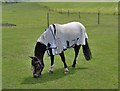
Grazing Pony, Newstead
I am not lifting my head for a photo ..... and yes it is this year's fashion !
Image: © Phil Evans
Taken: 24 Jul 2008
0.06 miles
8
The Robin Hood Line
Looking east to a train on the embankment of the Robin Hood Line, which runs north of Nottingham along the former Midland Railway main line. In the mist at the back are Robin Hood's Hills.
The Nottingham-Mansfield-Worksop passenger service was withdrawn in October 1964, closing this route which had existed for 115 years and leaving Mansfield as the largest town in Britain without a railway station. The track remained since it was required for coal traffic but goods yards were relentlessly closed along with some of the older collieries. The Annesley Tunnel and its approach cuttings were gradually filled with spoil and refuse.
European money for the project looked promising and in July 1990 an Act for the Newstead-Kirkby link was acquired by British Rail. The name 'Robin Hood Line' was adopted and a consortium of local authorities gave the final go-ahead a year later.
http://www.wagonplate9.co.uk/The%20Robin%20Hood%20Line/Robin%20Hood%20Line%20Web%20Pages/Construction.htm
http://www.wagonplate9.co.uk/The%20Robin%20Hood%20Line/Robin%20Hood%20Line%20Web%20Pages/Stage%202.htm
Image: © Trevor Rickard
Taken: 6 Feb 2010
0.10 miles
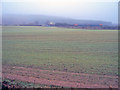
9

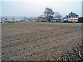
Fields near Annesley
Looking across the fields from the outskirts of Annesley towards the Robin Hood Line, with Robin Hood's Hills beyond.
Image: © Antony Dixon
Taken: 27 Jul 2016
0.11 miles
10

Not the proper footpath
The public right of way goes off to the right here, but it looks as if everybody cuts across this field.
Image: © Antony Dixon
Taken: 27 Jul 2016
0.12 miles