IMAGES TAKEN NEAR TO
Mount Hooton, NOTTINGHAM, NG1 4JF
Introduction
This page details the photographs taken nearby to Mount Hooton, NG1 4JF by members of the Geograph project.
The Geograph project started in 2005 with the aim of publishing, organising and preserving representative images for every square kilometre of Great Britain, Ireland and the Isle of Man.

There are currently over 7.5m images from over14,400 individuals and you can help contribute to the project by visiting https://www.geograph.org.uk
Image Map
Images are licensed for reuse under creativecommons.org/licenses/by-sa/2.0
Notes
- Clicking on the map will re-center to the selected point.
- The higher the marker number, the further away the image location is from the centre of the postcode.
Image Listing (278 Images Found)
Images are licensed for reuse under creativecommons.org/licenses/by-sa/2.0
Image
Details
Distance
1
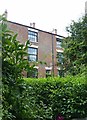
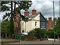
Mount Hooton, Forest Road East, Nottingham
A terrace of 10 houses, early 19th century, from before the later development of the area resulting from the Inclosure Act of 1845. Much concealed by vegetation. Listed Grade II.
Image: © Alan Murray-Rust
Taken: 12 Aug 2019
0.01 miles
2
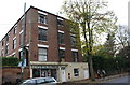
#69 Forest Road East at Mount Hooton
Image: © Roger Templeman
Taken: 3 Nov 2017
0.02 miles
3
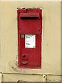
Forest Road East postbox, ref.NG1 12
This appears to a box of the Ludlow type with the enamel plate painted over. See https://www.geograph.org.uk/photo/5628048 for location.
Image: © Alan Murray-Rust
Taken: 12 Aug 2019
0.02 miles
4
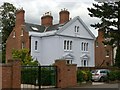
12 & 14 Forest Road East, Nottingham
One of a trio of similar villa pairs built c.1845, Listed Grade II.
Image: © Alan Murray-Rust
Taken: 12 Aug 2019
0.04 miles
5
8 & 10 Forest Road East, Nottingham
One of a trio of similar villa pairs built c.1845, Listed Grade II. This is the centre one and has different fenestration from the other two http://www.geograph.org.uk/photo/6239318 .
Image: © Alan Murray-Rust
Taken: 12 Aug 2019
0.04 miles
7
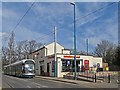
High School tram stop
With former pub in background, now Sainsbury's Local. Ticket machines awaiting activation.
Image: © Chris Morgan
Taken: 10 Mar 2014
0.05 miles
8
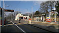
High School Tram Stop
A tram heading into the city centre pauses at the High School stop at the top of Waverley Street.
Image: © Stephen McKay
Taken: 3 Jul 2008
0.05 miles
9
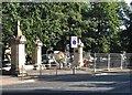
Restoration work at The Forest
Workmen at the Forest Road entrance to The Forest. The £5m Forest Restoration Project is financed by lottery funding, the city council and the Castle Cavendish Foundation, a local regeneration charity.
Image: © John Sutton
Taken: 14 Sep 2012
0.06 miles
10
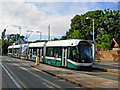
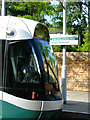
Waverley Street, Nottingham
After climbing steep Mount Hooton Road, a tram breasts the ridge before calling at the High School stop and then descending via Waverley Street to the city centre.
Image: © Stephen McKay
Taken: 3 Jul 2008
0.06 miles