IMAGES TAKEN NEAR TO
Forest Road East, NOTTINGHAM, NG1 4JE
Introduction
This page details the photographs taken nearby to Forest Road East, NG1 4JE by members of the Geograph project.
The Geograph project started in 2005 with the aim of publishing, organising and preserving representative images for every square kilometre of Great Britain, Ireland and the Isle of Man.

There are currently over 7.5m images from over14,400 individuals and you can help contribute to the project by visiting https://www.geograph.org.uk
Image Map
Images are licensed for reuse under creativecommons.org/licenses/by-sa/2.0
Notes
- Clicking on the map will re-center to the selected point.
- The higher the marker number, the further away the image location is from the centre of the postcode.
Image Listing (282 Images Found)
Images are licensed for reuse under creativecommons.org/licenses/by-sa/2.0
Image
Details
Distance
1
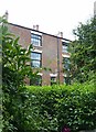
Mount Hooton, Forest Road East, Nottingham
A terrace of 10 houses, early 19th century, from before the later development of the area resulting from the Inclosure Act of 1845. Much concealed by vegetation. Listed Grade II.
Image: © Alan Murray-Rust
Taken: 12 Aug 2019
0.00 miles
2
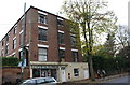
#69 Forest Road East at Mount Hooton
Image: © Roger Templeman
Taken: 3 Nov 2017
0.02 miles
3
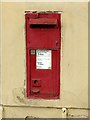
Forest Road East postbox, ref.NG1 12
This appears to a box of the Ludlow type with the enamel plate painted over. See https://www.geograph.org.uk/photo/5628048 for location.
Image: © Alan Murray-Rust
Taken: 12 Aug 2019
0.03 miles
4
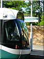
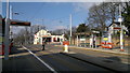
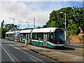
High School Tram Stop
A tram heading into the city centre pauses at the High School stop at the top of Waverley Street.
Image: © Stephen McKay
Taken: 3 Jul 2008
0.04 miles
5
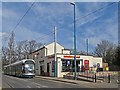
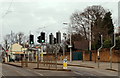
High School tram stop
With former pub in background, now Sainsbury's Local. Ticket machines awaiting activation.
Image: © Chris Morgan
Taken: 10 Mar 2014
0.04 miles
7
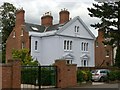
12 & 14 Forest Road East, Nottingham
One of a trio of similar villa pairs built c.1845, Listed Grade II.
Image: © Alan Murray-Rust
Taken: 12 Aug 2019
0.05 miles
8
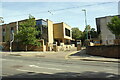
Entrance to Nottingham High School from Waverley Street
Ordnance Survey records indicate that a benchmark was levelled at 76.756m above Newlyn Datum in 1986 on the roadside wall to the left of the school entrance. The wall appears to have been rebuilt.
Image: © phil Richards
Taken: 14 Sep 2019
0.05 miles
9
Waverley Street, Nottingham
After climbing steep Mount Hooton Road, a tram breasts the ridge before calling at the High School stop and then descending via Waverley Street to the city centre.
Image: © Stephen McKay
Taken: 3 Jul 2008
0.05 miles
10
Waverley Mount, Nottingham
A view of the "High School" tram stop. The school site is behind the stone wall. In the distance is a 'Sainsbury's Local' supermarket that now occupies the former Vernon Arms public house. From 1650 this refreshment site operated as a coffee house and boasted a bowling green. What was then a narrow lane leading (downhill) to the city centre was called Bowling Alley Lane but its name was changed to Waverley Street in 1830. At about the same time - for some unknown reason - this former refreshment site became known as The Vernon Arms.
Image: © David Hallam-Jones
Taken: 13 Feb 2016
0.05 miles