IMAGES TAKEN NEAR TO
Forest Road East, NOTTINGHAM, NG1 4HT
Introduction
This page details the photographs taken nearby to Forest Road East, NG1 4HT by members of the Geograph project.
The Geograph project started in 2005 with the aim of publishing, organising and preserving representative images for every square kilometre of Great Britain, Ireland and the Isle of Man.

There are currently over 7.5m images from over14,400 individuals and you can help contribute to the project by visiting https://www.geograph.org.uk
Image Map
Images are licensed for reuse under creativecommons.org/licenses/by-sa/2.0
Notes
- Clicking on the map will re-center to the selected point.
- The higher the marker number, the further away the image location is from the centre of the postcode.
Image Listing (345 Images Found)
Images are licensed for reuse under creativecommons.org/licenses/by-sa/2.0
Image
Details
Distance
1
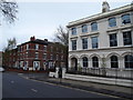
Nottingham - NG
Addison Street branching off from Forest Road East. The large white painted property (Nos 49-51) has been converted into offices and the Confederation of British Industries (East Midlands section) occupies space within it.
Image: © David Hallam-Jones
Taken: 28 Apr 2012
0.02 miles
2
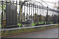
Cemetery wall of Forest Road East opposite Addison Street
There is an OS benchmark Image on the wall at the left hand side of the image
Image: © Roger Templeman
Taken: 9 Apr 2012
0.02 miles
3
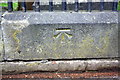
Benchmark on cemetery wall of Forest Road East
Ordnance Survey cut mark benchmark described on the Bench Mark Database at http://www.bench-marks.org.uk/bm42706
Image: © Roger Templeman
Taken: 8 Apr 2012
0.02 miles
5
![Church (Rock) Cemetery [2]](https://s1.geograph.org.uk/geophotos/05/34/90/5349069_00e8f5a4_120x120.jpg)
Church (Rock) Cemetery [2]
One of the pathways within the cemetery.
The cemetery of some 13 acres was created on the site of an old sand mine run by a man named Rouse, and laid out around the many sandstone outcrops — hence the popular name of Rock Cemetery. The cemetery is on the Register of Historic Parks and Gardens, grade II*, and there is much history and detail at: https://historicengland.org.uk/listing/the-list/list-entry/1001486
Image: © Michael Dibb
Taken: 31 Mar 2017
0.05 miles
6
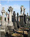
In Church (Rock) Cemetery
There is no shortage of gesticulating seraphs among the High Victorian monuments in this large cemetery, which was developed on the site of sand mines and quarries.
Image: © John Sutton
Taken: 1 Jul 2015
0.05 miles
7
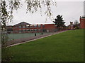
Nottingham - NG5
One of the teaching blocks and the tennis courts of Nottingham Girls' High School taken from Baker Street - a short cul-de-sac - used by bus drivers when picking pupils up. The tower in the distance is on the Nottingham (Boys’) High School site from where it overlooks the city centre.
Image: © David Hallam-Jones
Taken: 28 Apr 2012
0.05 miles
8
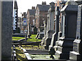
Church Cemetery
Looking towards Forest Road East.
Image: © Alan Murray-Rust
Taken: 8 Mar 2009
0.05 miles
9
In Church Cemetery
This cemetery contains a fine collection of Victorian funerary art.
Image: © Alan Murray-Rust
Taken: 8 Mar 2009
0.05 miles
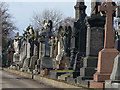
10
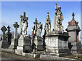
Victorian graves
A fine selection of ornate Victorian graves and monuments in Church Cemetery
Image: © Alan Murray-Rust
Taken: 8 Mar 2009
0.05 miles