IMAGES TAKEN NEAR TO
Forest Grove, NOTTINGHAM, NG1 4HS
Introduction
This page details the photographs taken nearby to Forest Grove, NG1 4HS by members of the Geograph project.
The Geograph project started in 2005 with the aim of publishing, organising and preserving representative images for every square kilometre of Great Britain, Ireland and the Isle of Man.

There are currently over 7.5m images from over14,400 individuals and you can help contribute to the project by visiting https://www.geograph.org.uk
Image Map
Images are licensed for reuse under creativecommons.org/licenses/by-sa/2.0
Notes
- Clicking on the map will re-center to the selected point.
- The higher the marker number, the further away the image location is from the centre of the postcode.
Image Listing (363 Images Found)
Images are licensed for reuse under creativecommons.org/licenses/by-sa/2.0
Image
Details
Distance
2
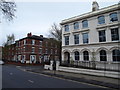
Nottingham - NG
Addison Street branching off from Forest Road East. The large white painted property (Nos 49-51) has been converted into offices and the Confederation of British Industries (East Midlands section) occupies space within it.
Image: © David Hallam-Jones
Taken: 28 Apr 2012
0.03 miles
3
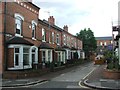
Tudor Grove
Facing terraces with an alleyway between. Nottingham expanded northwards from its mediaeval core in the years after the 1845 Enclosure Act.
Image: © John Sutton
Taken: 12 May 2018
0.05 miles
4
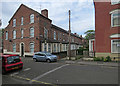
Colville Terrace
Nottingham expanded northwards from its mediaeval core in the years after the 1845 Enclosure Act.
Image: © John Sutton
Taken: 12 May 2018
0.05 miles
5
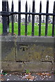
Benchmark on cemetery wall opposite #19 Forest Road East
Ordnance Survey cut mark benchmark described on the Bench Mark Database at http://www.bench-marks.org.uk/bm42707
Image: © Roger Templeman
Taken: 8 Apr 2012
0.05 miles
6
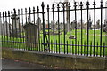
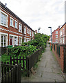
Cemetery wall of Forest Road East
There is an OS benchmark Image on the wall in the middle of the image
Image: © Roger Templeman
Taken: 9 Apr 2012
0.05 miles
7
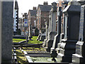
Church Cemetery
Looking towards Forest Road East.
Image: © Alan Murray-Rust
Taken: 8 Mar 2009
0.05 miles
8
![Church (Rock) Cemetery [2]](https://s1.geograph.org.uk/geophotos/05/34/90/5349069_00e8f5a4_120x120.jpg)
Church (Rock) Cemetery [2]
One of the pathways within the cemetery.
The cemetery of some 13 acres was created on the site of an old sand mine run by a man named Rouse, and laid out around the many sandstone outcrops — hence the popular name of Rock Cemetery. The cemetery is on the Register of Historic Parks and Gardens, grade II*, and there is much history and detail at: https://historicengland.org.uk/listing/the-list/list-entry/1001486
Image: © Michael Dibb
Taken: 31 Mar 2017
0.06 miles
9
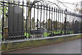
Cemetery wall of Forest Road East opposite Addison Street
There is an OS benchmark Image on the wall at the left hand side of the image
Image: © Roger Templeman
Taken: 9 Apr 2012
0.06 miles
10
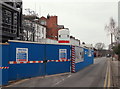
Arboretum Street, Nottingham.
From its Addison Street end to its Waverley Street end in the distance this image shows clearly how most of the southern side of the road is occupied by buildings belonging to The Girls' High School. The construction site entrance for the new Performing Arts Centre is clearly obvious. Although members of the Arboretum Tenants' and Residents' Association expressed concern that this development would lead to increased traffic, noise pollution and be out of keeping with the Victorian architecture of Addison Street, the Council gave permission for it. The premises are expected to provide better accommodation for pupils for performances, assemblies and teaching. It will include a 275 seat auditorium, improved back-of-house facilities and a reception foyer. In addition, a smaller 70 seat studio will provide for smaller performances. The facilities will be predominantly for school use, although will include an ancillary element to provide for commercial and community use, i.e. occasional performances or rehearsals by external theatre companies, amateur dramatic groups, local schools or by local community groups. The budget is approximately £6.5m and it is due to be completed in 2016.
Image: © David Hallam-Jones
Taken: 13 Feb 2016
0.06 miles