IMAGES TAKEN NEAR TO
North Sherwood Street, NOTTINGHAM, NG1 4EL
Introduction
This page details the photographs taken nearby to North Sherwood Street, NG1 4EL by members of the Geograph project.
The Geograph project started in 2005 with the aim of publishing, organising and preserving representative images for every square kilometre of Great Britain, Ireland and the Isle of Man.

There are currently over 7.5m images from over14,400 individuals and you can help contribute to the project by visiting https://www.geograph.org.uk
Image Map
Images are licensed for reuse under creativecommons.org/licenses/by-sa/2.0
Notes
- Clicking on the map will re-center to the selected point.
- The higher the marker number, the further away the image location is from the centre of the postcode.
Image Listing (547 Images Found)
Images are licensed for reuse under creativecommons.org/licenses/by-sa/2.0
Image
Details
Distance
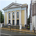
3

Nottingham Hebrew Congregation Synagogue
On Shakespeare Street. Built as a Wesleyan Reform chapel. Now synagogue.
Enter into his gates with thanksgiving and on CCTV.
Grade II listed List entry Number: 1255018 https://historicengland.org.uk/listing/the-list/list-entry/1255018
Image: © David Lally
Taken: 20 Apr 2013
0.05 miles
4
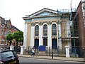
Repairs at the Hebrew Congregation Synagogue
'Enter into his gates with thanksgiving' and under his scaffolding with care.
Image: © Christine Johnstone
Taken: 5 Jun 2013
0.05 miles
5
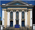
Former Wesleyan Reform Church, Shakespeare Street, Nottingham
A majestic facade, resplendent in brown, white and blue, a pediment above its dominant fluted Corinthian pilasters. By Thomas Simpson, 1854. Grade II listed.
It switched sides, so to speak, in 1954 when it became a synagogue.
Image: © Stephen Richards
Taken: 19 Jun 2012
0.05 miles
6
University Hall - a recycled place of worship
Built as a Wesleyan Church, it was until recently an Orthodox Synagogue. It is to be the centre for Nottingham Trent University Music. For more about it, see Stephen Richards' Image] (2012).
Image: © John Sutton
Taken: 11 Sep 2018
0.05 miles
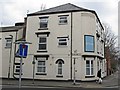
7
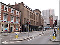
Nottingham - NG1
One aspect of the Mansfield Road (A60) end of Shakespeare Street, showing the long 1943 "rebuilt" YMCA premises. The building currently housing the "Age UK" organisation is evidently much older. In the distance and in front of the monstrous block of flats in NG3 is all that remains of the former Victoria Station, the clock tower that has been preserved as a feature of the Victoria Shopping Centre.
Image: © David Hallam-Jones
Taken: 18 May 2012
0.05 miles
8
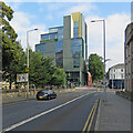
Nottingham School of Art & Design
A recent addition to Nottingham Trent University, at the corner of Shakespeare Street and North Sherwood Street.
Image: © John Sutton
Taken: 31 Aug 2024
0.05 miles
9
University Hall, Shakespeare Street
On the occasion of the Graduation ceremonies of 2019, one of the main purposes for which the Nottingham Trent University took over the building in 2017. Built in 1854 as a Methodist chapel, it later became a Synagogue https://www.geograph.org.uk/photo/3506874
Image: © Alan Murray-Rust
Taken: 26 Jul 2019
0.05 miles
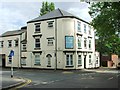
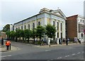
10
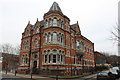
Nottingham Registry Office
Built as the Poor Law Offices by Abraham Harrison Goodall. 1885-86.
Image: © Andrew Abbott
Taken: 14 Jan 2018
0.05 miles