IMAGES TAKEN NEAR TO
North Sherwood Street, NOTTINGHAM, NG1 4EF
Introduction
This page details the photographs taken nearby to North Sherwood Street, NG1 4EF by members of the Geograph project.
The Geograph project started in 2005 with the aim of publishing, organising and preserving representative images for every square kilometre of Great Britain, Ireland and the Isle of Man.

There are currently over 7.5m images from over14,400 individuals and you can help contribute to the project by visiting https://www.geograph.org.uk
Image Map
Images are licensed for reuse under creativecommons.org/licenses/by-sa/2.0
Notes
- Clicking on the map will re-center to the selected point.
- The higher the marker number, the further away the image location is from the centre of the postcode.
Image Listing (285 Images Found)
Images are licensed for reuse under creativecommons.org/licenses/by-sa/2.0
Image
Details
Distance
1
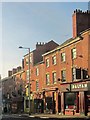
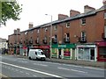
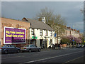
Shops on Mansfield Road, Nottingham
See http://www.geograph.org.uk/search.php?i=5550541 for an interesting comparison of the buildings along the A60 in this area. The terrace, dating from about 1845, is listed http://list.english-heritage.org.uk/resultsingle.aspx?uid=1254760&searchtype=mapsearch . A cosmopolitan area: Dalyan is a Turkish restaurant named after the town on the Turkish coast while Jalisco, next door, is a Mexican restaurant named after a state in that country.
Image: © Derek Harper
Taken: 12 Oct 2014
0.01 miles
2
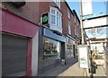
Prickly Pear vegan eatery on Mansfield Road, Nottingham
More and more vegan eateries are springing up everywhere.
Image: © Jeremy Bolwell
Taken: 18 Jan 2020
0.01 miles
3
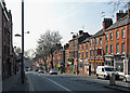
Mansfield Road, Nottingham
Seen from Frogmore Street (http://www.geograph.org.uk/search.php?i=51853986 ). Apologies for the quality - taken through a car windscreen, hence the reflection - but it does show a different angle on a sunny day, with a continental supermarket and cafe opposite the Nag's Head pub on the right.
Image: © Derek Harper
Taken: 12 Oct 2014
0.03 miles
4
On Mansfield Road
A variety of shops and restaurants occupy the nineteenth-century buildings on the right-hand side. The pub behind the white van is The Lincolnshire Poacher.
Image: © John Sutton
Taken: 23 Apr 2010
0.03 miles
5
107 to 125, Mansfield Road, Nottingham
Classic Victorian retail and residential development on a main arterial road. Built c.1845, Listed Grade II.
Image: © Alan Murray-Rust
Taken: 26 Jul 2019
0.03 miles
6
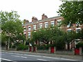
110 to 138, Mansfield Road, Nottingham
A terrace of 14 town houses, built c.1840, Listed Grade II. Generally converted to offices in the late 20th century, although the centre pair have recently found a new use as a boutique guest house.
Image: © Alan Murray-Rust
Taken: 26 Jul 2019
0.03 miles
7
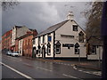
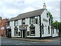
Nottingham - NG1
The Nag's Head pub on the junction of Frogmore Street with Mansfield Road (A60). This former coaching inn dates back to the C15th. In the days when hangings took place on the former "Gallows Hill", near to where St Andrew’s Church is located today, execution processions often used to stop here to allow the condemned prisoner a final drink, one that was paid for by the landlord. Parts of the building date back to 1752. The premises were converted in student accommodation in 2020.
Image: © David Hallam-Jones
Taken: 21 Apr 2012
0.03 miles
8
Nottingham - NG1
The junction of Frogmore Street with Mansfield Rd (A60) on the left of the picture and The Nag's Head pub, a former coaching inn.
Image: © David Hallam-Jones
Taken: 21 Apr 2012
0.03 miles
10
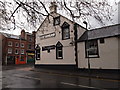
Nag's Head, Mansfield Road
An unspoilt-looking pub close to the City Centre, where most pubs have been 'modernised' with new names.
Image: © Alan Murray-Rust
Taken: 2 May 2008
0.04 miles