IMAGES TAKEN NEAR TO
North Church Street, NOTTINGHAM, NG1 4BR
Introduction
This page details the photographs taken nearby to North Church Street, NG1 4BR by members of the Geograph project.
The Geograph project started in 2005 with the aim of publishing, organising and preserving representative images for every square kilometre of Great Britain, Ireland and the Isle of Man.

There are currently over 7.5m images from over14,400 individuals and you can help contribute to the project by visiting https://www.geograph.org.uk
Image Map
Images are licensed for reuse under creativecommons.org/licenses/by-sa/2.0
Notes
- Clicking on the map will re-center to the selected point.
- The higher the marker number, the further away the image location is from the centre of the postcode.
Image Listing (1143 Images Found)
Images are licensed for reuse under creativecommons.org/licenses/by-sa/2.0
Image
Details
Distance
1
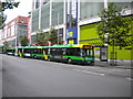
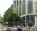
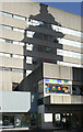
Many buses on Milton Street, Nottingham
No fewer than four buses await their departure times from Milton Street on services via Sherwood Rise (the fifth bus in the background on the left is on a Hucknall Road route). Behind them is the northern part of the Trinity Square development, which contains shops, a car park and student accommodation.
Image: © Richard Vince
Taken: 31 Aug 2011
0.00 miles
3
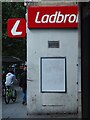
Side of a Ladbrokes
Betting shop on Milton Street, on the outside of the "Vikki" centre.
Image: © David Lally
Taken: 9 Aug 2021
0.01 miles
4
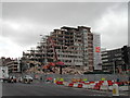
Demise of Mechanics Institute
On the corner of Milton Street and Trinity Square
Image: © Tom Courtney
Taken: 3 Jun 2005
0.02 miles
5
"Demise of Mechanics Institute"
Recreating this 'First' for the square http://www.geograph.org.uk/photo/35543 .
Obviously the title of the original caught a transient moment in the redevelopment of the area, which has changed out of all recognition. The only link to the old view is the street layout and the older building which can be seen between the trees right on the left edge of my picture.
Image: © Alan Murray-Rust
Taken: 29 Jul 2021
0.02 miles
6
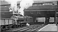
Southward into the tunnels from Nottingham Victoria, with Up ore empties
View from Platform 4 towards Leicester Central and London Marylebone on the ex-GC main line, also Colwick Yards and Grantham on the ex-GN. The signalbox in the gloom between the Parliament Street bridge and Thurland Street tunnel is Nottingham Victoria South. The ore empties, probably bound for Colwick, is being worked tender-first by O4/1 2-8-0 No. 63707. This engine ended its days in 7/65 unrebuilt, having been No. 3540 (for three months) in 1946-7 and No. 6193 in 10/24, having been built for the GCR in 9/1912 as No. 1193 and was not one of the many built for the Government in World War 1.
Image: © Ben Brooksbank
Taken: 12 Oct 1962
0.03 miles
7
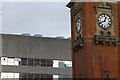
Victoria Clock Tower
A remnant of the Victoria Railway Station. Now surrounded on three sides by the station's replacement The Victoria Shopping Centre.
Image: © David Lally
Taken: 8 Feb 2014
0.03 miles
8
Nottingham - Shakespeare Street & Clock Tower
Image: © Colin Park
Taken: 8 Mar 1980
0.03 miles
9
Shadow and reflection . . .
. . . are still enough to identify the Victoria Clock Tower. The building is an office block forming part of the Victoria Centre complex which replaced the Victoria Railway Station.
Image: © Alan Murray-Rust
Taken: 8 Mar 2009
0.03 miles
10
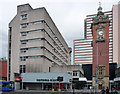
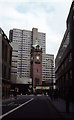
Victoria Centre and Clock Tower, Milton Street, Nottingham
The clock tower is the only fragment of Victoria Station to survive redevelopment which produced the shopping centre complex in 1965-72. It was built in 1898-1900 by A.E. Lambert. Grade II listed.
Behind are another element of the scheme, flats (Image]).
Another view: Image
Image: © Stephen Richards
Taken: 17 Jun 2012
0.03 miles