IMAGES TAKEN NEAR TO
Shakespeare Street, NOTTINGHAM, NG1 4AH
Introduction
This page details the photographs taken nearby to Shakespeare Street, NG1 4AH by members of the Geograph project.
The Geograph project started in 2005 with the aim of publishing, organising and preserving representative images for every square kilometre of Great Britain, Ireland and the Isle of Man.

There are currently over 7.5m images from over14,400 individuals and you can help contribute to the project by visiting https://www.geograph.org.uk
Image Map
Images are licensed for reuse under creativecommons.org/licenses/by-sa/2.0
Notes
- Clicking on the map will re-center to the selected point.
- The higher the marker number, the further away the image location is from the centre of the postcode.
Image Listing (667 Images Found)
Images are licensed for reuse under creativecommons.org/licenses/by-sa/2.0
Image
Details
Distance
1
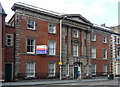
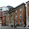
14-22 Shakespeare Street, Nottingham
Quite a good piece of Victorian Classicism. Orange-red brick with an attached Corinthian portico in stone. Thomas Simpson may have been the architect. Built c1853-54. Grade II listed.
Formerly home to the University of Nottingham's Adult Education Centre, but empty at the time of the photo.
Image: © Stephen Richards
Taken: 18 Jun 2012
0.01 miles
2
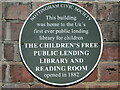
Plaque on Bard House, Shakespeare Street
Site of UK's first public lending library for children.
Image: © El Loco
Taken: 22 Jun 2022
0.01 miles
3
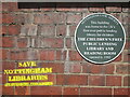
Plaque with graffiti on Bard House
Zooming out from shot Image
Image: © El Loco
Taken: 22 Jun 2022
0.01 miles
4
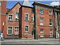
Bard House, Shakespeare Street, Nottingham
Left hand frontage of building showing location of Image on site of the UK's first public lending library for children. The building has been converted to student accommodation.
Image: © El Loco
Taken: 22 Jun 2022
0.01 miles
5
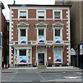
Bard House, Shakespeare Street, Nottingham
Built c.1850 as a large town house, later an adult education centre for the University of Nottingham. Empty at the time of Stephen Richard's photo in 2012 https://www.geograph.org.uk/photo/4113722 it has now been reconverted to residential use as student accommodation. Listed Grade II.
Image: © Alan Murray-Rust
Taken: 26 Jul 2019
0.01 miles
6
12 Shakespeare Street, Nottingham
Town house of c.1850, converted to offices late 20th century, Listed Grade II.
Image: © Alan Murray-Rust
Taken: 26 Jul 2019
0.01 miles
7
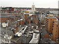
Nottingham Cityscape
Looking towards Nottingham Trent University
Image: © Andy Jamieson
Taken: 25 Feb 2008
0.02 miles
8
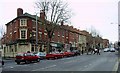
Mansfield Road, Nottingham, & The Peacock
The A 60, major route into Nottingham from the north, seen here in the city centre, looking NNW.
Image: © Lynne Kirton
Taken: 22 Dec 2005
0.02 miles
9
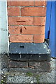
Benchmark on the Peachey Street face of the YMCA
Ordnance Survey cut mark benchmark described on the Bench Mark Database at http://www.bench-marks.org.uk/bm47849
Image: © Roger Templeman
Taken: 30 Mar 2013
0.02 miles
10
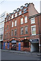
YMCA Building, Peachey Street
There is an OS benchmark Image on the bricks to the left of the leftmost blue door
Image: © Roger Templeman
Taken: 30 Mar 2013
0.02 miles