IMAGES TAKEN NEAR TO
Old Tannery Drive, NOTTINGHAM, NG14 7PS
Introduction
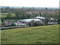
This page details the photographs taken nearby to Old Tannery Drive, NG14 7PS by members of the Geograph project.
The Geograph project started in 2005 with the aim of publishing, organising and preserving representative images for every square kilometre of Great Britain, Ireland and the Isle of Man.

There are currently over 7.5m images from over14,400 individuals and you can help contribute to the project by visiting https://www.geograph.org.uk
Image Map
Images are licensed for reuse under creativecommons.org/licenses/by-sa/2.0
Notes
- Clicking on the map will re-center to the selected point.
- The higher the marker number, the further away the image location is from the centre of the postcode.
Image Listing (56 Images Found)
Images are licensed for reuse under creativecommons.org/licenses/by-sa/2.0
Image
Details
Distance
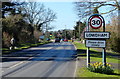
1
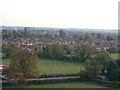
Housing at Lowdham
Modern developments for Nottingham commuters on the south side of the village.
Image: © Alan Murray-Rust
Taken: 13 Oct 2009
0.07 miles
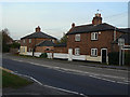
2
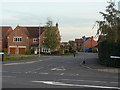
Old Tannery Drive
The newest significant housing development in the village, designed for commuters into Nottingham.
Image: © Alan Murray-Rust
Taken: 13 Oct 2009
0.08 miles
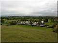
3
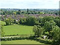
Dormitory development, Lowdham
A substantial 'suburban' style development of the late 20th century for Nottingham commuters.
Image: © Alan Murray-Rust
Taken: 13 Jun 2020
0.09 miles
4
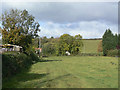
Bridleway near Lowdham
This bridleway passes down the east side of the village. Barker Hill in the background.
Image: © Alan Murray-Rust
Taken: 16 Oct 2009
0.09 miles
5
Car showroom and service station, Lowdham
The steep scarp marks the edge of the flat bottom of the valley of the River Trent. The high ground is formed by deposits of mudstones which have been eroded by the river to form these steep slopes.
Image: © Alan Murray-Rust
Taken: 13 Oct 2009
0.11 miles
7
On the south east slope of Barker Hill
On a path from Lowdham towards Gonalston, a car showroom on the main road.
Image: © Peter Barr
Taken: 12 Oct 2011
0.14 miles
8
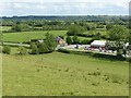
View across the Trent Valley from Barker Hill
The steep slope in the foreground is the river cut, matching the scarp visible on the far side of the alluvial valley floor. The modern course of the River Trent is on the far side.
Image: © Alan Murray-Rust
Taken: 13 Jun 2020
0.17 miles
9
Cottages at Lowdham
An attractive double pair of 19th century cottages fronting the main Southwell Road in Lowdham.
Image: © Alan Murray-Rust
Taken: 13 Oct 2009
0.17 miles
10
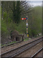
Lowdham Down Starting signal
This is the last remaining semaphore signal worked by Lowdham box and will disappear when the new signalling is installed.
Image: © Alan Murray-Rust
Taken: 6 Apr 2014
0.18 miles