IMAGES TAKEN NEAR TO
Gonalston Lane, NOTTINGHAM, NG14 7LL
Introduction
This page details the photographs taken nearby to Gonalston Lane, NG14 7LL by members of the Geograph project.
The Geograph project started in 2005 with the aim of publishing, organising and preserving representative images for every square kilometre of Great Britain, Ireland and the Isle of Man.

There are currently over 7.5m images from over14,400 individuals and you can help contribute to the project by visiting https://www.geograph.org.uk
Image Map
Images are licensed for reuse under creativecommons.org/licenses/by-sa/2.0
Notes
- Clicking on the map will re-center to the selected point.
- The higher the marker number, the further away the image location is from the centre of the postcode.
Image Listing (27 Images Found)
Images are licensed for reuse under creativecommons.org/licenses/by-sa/2.0
Image
Details
Distance
1
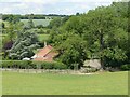
Hermitage, Gonalston
Looking down from the end of Barker Hill.
Image: © Alan Murray-Rust
Taken: 13 Jun 2020
0.00 miles
2
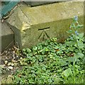
Bench mark, bridge over the Dover Beck, Gonalston
See http://www.geograph.org.uk/photo/6508440 for location.
Image: © Alan Murray-Rust
Taken: 13 Jun 2020
0.01 miles
3
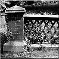
Bridge over the Dover Beck, Gonalston
Detail of the parapet, cast iron top rail and wrought iron lattioce. Built around 1900.
Image: © Alan Murray-Rust
Taken: 13 Jun 2020
0.01 miles
4
Cast iron railings on small road bridge
Over a brook at The Hermitage, a house near Gonalston.
Image: © Peter Barr
Taken: 12 Oct 2011
0.02 miles
5
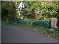
Bridge over the Dover Beck
An attractive example of Victorian ironwork at The Hermitage, Gonalston.
Image: © Alan Murray-Rust
Taken: 13 Oct 2009
0.02 miles
6
The Hermitage, Gonalston
Looking down from the footpath up onto Barker Hill.
Image: © Alan Murray-Rust
Taken: 13 Oct 2009
0.02 miles
7
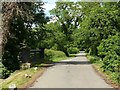
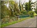
The old road to Southwell
This was the main road between Nottingham and Southwell prior to the construction of the Gonalston bypass in the 1930s. There is a benchmark http://www.geograph.org.uk/photo/6508444 on the far end of the left hand parapet.
Image: © Alan Murray-Rust
Taken: 13 Jun 2020
0.04 miles
8
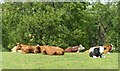
Contented cattle
Above Hermitage near Gonalston.
Image: © Alan Murray-Rust
Taken: 13 Jun 2020
0.11 miles
9
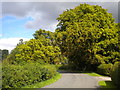
The south western approach to Gonalston
A very verdant way to enter a village.
Image: © Richard Vince
Taken: 23 Aug 2014
0.14 miles
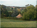
10
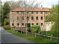
Cliff Mill, Gonalston
There are records of a mill on this site from medieval times, possibly as early as the 12th century, and certainly from the 14th when it was attached to Thurgarton Priory. The present building dates from the late 18th century, built as a cotton spinning mill, and is Listed Grade II. It was refurbished as residential property around 1975. It is one of 12 mills on the Dover Beck in just over 10km as the crow flies, which are described in detail in this link https://www.woodborough-heritage.org.uk/millsonthedoverbeck.html
The building shows to better effect at this time of year compared with trhis September view http://www.geograph.org.uk/photo/1508222
Image: © Alan Murray-Rust
Taken: 28 Apr 2021
0.14 miles