IMAGES TAKEN NEAR TO
Hoveringham Lane, NOTTINGHAM, NG14 7JX
Introduction
This page details the photographs taken nearby to Hoveringham Lane, NG14 7JX by members of the Geograph project.
The Geograph project started in 2005 with the aim of publishing, organising and preserving representative images for every square kilometre of Great Britain, Ireland and the Isle of Man.

There are currently over 7.5m images from over14,400 individuals and you can help contribute to the project by visiting https://www.geograph.org.uk
Image Map
Images are licensed for reuse under creativecommons.org/licenses/by-sa/2.0
Notes
- Clicking on the map will re-center to the selected point.
- The higher the marker number, the further away the image location is from the centre of the postcode.
Image Listing (6 Images Found)
Images are licensed for reuse under creativecommons.org/licenses/by-sa/2.0
Image
Details
Distance
1
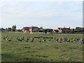
Coneygre Farm
In the foreground is part of a large flock of Canada Geese, (around 200), clearly resident on the neighbouring gravel pits.
Image: © Alan Murray-Rust
Taken: 13 Oct 2009
0.02 miles
2
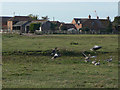
Greylags near Coneygre Farm
There was a large flock of some 200 Canada Geese grazing in this field, but amongst them was this small group of about 20 Greylag Geese, who were far less enthusiastic about my presence. I wonder whether they will be resident in the area or were just passing through?
Image: © Alan Murray-Rust
Taken: 13 Oct 2009
0.13 miles
3
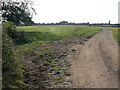
Diverging bridleway
The bridleway follows the hedge at the left, and does not continue along the obvious track which it has followed for the last half-mile or more. Clearly many people have missed this, so the farmer has installed his own directions http://www.geograph.org.uk/photo/1536121, http://www.geograph.org.uk/photo/1536137
Image: © Alan Murray-Rust
Taken: 13 Oct 2009
0.19 miles
4
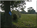
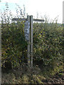
Unofficial waymark
Doubtless installed by the local farmer as a result of people walking and riding along the road to the farm http://www.geograph.org.uk/photo/1536127.
Image: © Alan Murray-Rust
Taken: 13 Oct 2009
0.19 miles
5
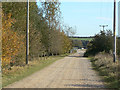
Lane to the Nottinghamshire Sailing Club
This was doubtless originally an access road for the gravel extraction company before these former gravel pits were given over to the club.
Image: © Alan Murray-Rust
Taken: 13 Oct 2009
0.23 miles
6
Helpful notice
At this point the bridleway diverges from the farm track that it has been following from Gibsmere and becomes a far from obvious field edge path http://www.geograph.org.uk/photo/1536127.
Image: © Alan Murray-Rust
Taken: 13 Oct 2009
0.24 miles