IMAGES TAKEN NEAR TO
Kneeton View, NOTTINGHAM, NG14 7JU
Introduction
This page details the photographs taken nearby to Kneeton View, NG14 7JU by members of the Geograph project.
The Geograph project started in 2005 with the aim of publishing, organising and preserving representative images for every square kilometre of Great Britain, Ireland and the Isle of Man.

There are currently over 7.5m images from over14,400 individuals and you can help contribute to the project by visiting https://www.geograph.org.uk
Image Map
Images are licensed for reuse under creativecommons.org/licenses/by-sa/2.0
Notes
- Clicking on the map will re-center to the selected point.
- The higher the marker number, the further away the image location is from the centre of the postcode.
Image Listing (40 Images Found)
Images are licensed for reuse under creativecommons.org/licenses/by-sa/2.0
Image
Details
Distance
1
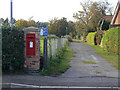
Postbox, Hoveringham (ref NG14 318)
George V wall box mounted in its own brick pillar. This could well be a replacement location following the closure of the local Post Office.
Behind is Chapel Field, the village Recreation Ground.
Image: © Alan Murray-Rust
Taken: 13 Oct 2009
0.01 miles
2
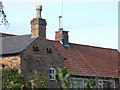
Dovecote at Hoveringham
The building is an old coach house, probably mid to late 19th century, which makes these dove holes an unusual feature.
Image: © Alan Murray-Rust
Taken: 13 Oct 2009
0.02 miles
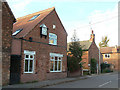
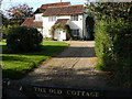
3
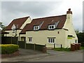
Homeleigh, Main Street, Hoveringham
Almost certainly the oldest building in the village. It consists of a 17th century timber frame hall house subsequently enclosed with brick, with a modern extension to the left, apparently built in the 1990s. Listed Grade II, the listing, from 1991, refers to a porch and bay window on this side of the building, and makes no mention of the new section.
Image: © Alan Murray-Rust
Taken: 17 May 2021
0.02 miles
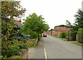
4
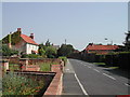
Main Street, Hoveringham
Hall Farm is top right and Flora Farm to the left
Image: © Tom Courtney
Taken: 17 Aug 2005
0.03 miles
5
The old Post Office?
The evidence of a doorway onto the street and what could have been a shop window, the clock, and the fact that the lane just beyond is called Post Office Yard, suggest that this may have been the village Post Office.
Image: © Alan Murray-Rust
Taken: 13 Oct 2009
0.05 miles
6
Main Street, Hoveringham
Recreating this 'First' for the square https://www.geograph.org.uk/photo/38946
Image: © Alan Murray-Rust
Taken: 15 Jul 2021
0.05 miles
7
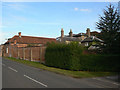
Hoveringham Hall
A large Victorian house which clearly turns its back on the village; the road is lined with high brick walls.
Image: © Alan Murray-Rust
Taken: 13 Oct 2009
0.06 miles
8
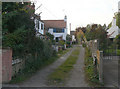
Post Office Yard
The village no longer has a Post Office, but clearly did at one time.
Image: © Alan Murray-Rust
Taken: 13 Oct 2009
0.06 miles
10
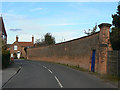
Hall wall
One wonders why the owner of Hoveringham Hall needed to make the wall quite so high.
Image: © Alan Murray-Rust
Taken: 13 Oct 2009
0.07 miles