IMAGES TAKEN NEAR TO
Priory Park, NOTTINGHAM, NG14 7HE
Introduction
This page details the photographs taken nearby to Priory Park, NG14 7HE by members of the Geograph project.
The Geograph project started in 2005 with the aim of publishing, organising and preserving representative images for every square kilometre of Great Britain, Ireland and the Isle of Man.

There are currently over 7.5m images from over14,400 individuals and you can help contribute to the project by visiting https://www.geograph.org.uk
Image Map
Images are licensed for reuse under creativecommons.org/licenses/by-sa/2.0
Notes
- Clicking on the map will re-center to the selected point.
- The higher the marker number, the further away the image location is from the centre of the postcode.
Image Listing (75 Images Found)
Images are licensed for reuse under creativecommons.org/licenses/by-sa/2.0
Image
Details
Distance
1
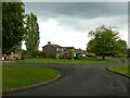
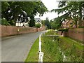
Priory Park, Thurgarton
Late 20th century development of generally larger houses with a larger amount of open space than is generally included in modern developments.
Image: © Alan Murray-Rust
Taken: 19 May 2021
0.02 miles
3
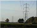
Pylons near Thurgarton
One of the links between Ratcliffe-on-Soar Power Station and the switching station at the site of the former Staythorpe Power Station.
Image: © Alan Murray-Rust
Taken: 13 Oct 2009
0.08 miles
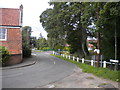
4
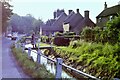
Beck Street, Thurgarton
Taking its name from the stream – the Thurgarton Beck – which it runs alongside.
Image: © Alan Murray-Rust
Taken: 19 May 2021
0.08 miles
5
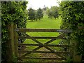
Bridleway gate?
Current mapping still shows a public bridleway across this land which is now effectively private garden. At the far end there was clearly formerly access to Beck Street via the farmyard of Manor Farm which never became a right of way, leaving the bridleway as a stub. The farm track that it followed subsequently became redundant when the farm ceased to be a working farm and has disappeared completely, although still showing on aerial images from the early 21st century.
Image: © Alan Murray-Rust
Taken: 19 May 2021
0.08 miles
6
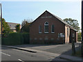
The Methodist Church, Thurgarton
An unassuming church; the central foundation stone carries the date 1927.
Image: © Alan Murray-Rust
Taken: 13 Oct 2009
0.09 miles
7
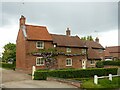
Sycamore Cottage, Beck Street
Late 18th century cottage with 19th century extensions, Listed Grade II.
Image: © Alan Murray-Rust
Taken: 19 May 2021
0.09 miles
10
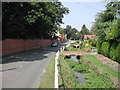
Thurgarton Village, Beck Street
Recreating this 'First' for the square https://www.geograph.org.uk/photo/38952
Image: © Alan Murray-Rust
Taken: 15 Jul 2021
0.10 miles