IMAGES TAKEN NEAR TO
Bleasby, NOTTINGHAM, NG14 7FR
Introduction
This page details the photographs taken nearby to NG14 7FR by members of the Geograph project.
The Geograph project started in 2005 with the aim of publishing, organising and preserving representative images for every square kilometre of Great Britain, Ireland and the Isle of Man.

There are currently over 7.5m images from over14,400 individuals and you can help contribute to the project by visiting https://www.geograph.org.uk
Image Map
Images are licensed for reuse under creativecommons.org/licenses/by-sa/2.0
Notes
- Clicking on the map will re-center to the selected point.
- The higher the marker number, the further away the image location is from the centre of the postcode.
Image Listing (18 Images Found)
Images are licensed for reuse under creativecommons.org/licenses/by-sa/2.0
Image
Details
Distance
2

A row of pine trees near High Cross Farm
Image: © Jonathan Thacker
Taken: 27 Nov 2019
0.08 miles
3
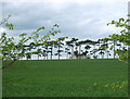
Line of Pines
A distinctive row of planted pine trees, between Goverton and Halloughton.
Image: © Ajay Tegala
Taken: 20 May 2008
0.09 miles
4
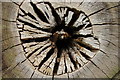
Bullseye
Before the days of Jocky Wilson, archers used the end of sawn-off tree trunks for practising their "arrows". This one has long passed its sell-by date!
Image: © Ian Paterson
Taken: 29 Apr 2007
0.13 miles
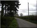
5
High Cross north of Thurgarton (1)
Looking towards the A612 under threatening skies.
Image: © Richard Vince
Taken: 6 Apr 2014
0.14 miles
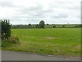
6
High Cross north of Thurgarton (2)
Looking towards Goverton and Bleasby.
Image: © Richard Vince
Taken: 6 Apr 2014
0.15 miles
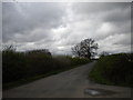
7
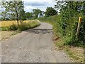
The road from Rudsey Farm
This section is also a public footpath.
Image: © Alan Murray-Rust
Taken: 2 Aug 2020
0.16 miles

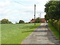
10
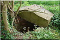
Disused well at edge of field
This is located adjacent to the public footpath
Image: © Ian Paterson
Taken: 29 Apr 2007
0.17 miles