IMAGES TAKEN NEAR TO
Thurgarton, NOTTINGHAM, NG14 7FQ
Introduction
This page details the photographs taken nearby to NG14 7FQ by members of the Geograph project.
The Geograph project started in 2005 with the aim of publishing, organising and preserving representative images for every square kilometre of Great Britain, Ireland and the Isle of Man.

There are currently over 7.5m images from over14,400 individuals and you can help contribute to the project by visiting https://www.geograph.org.uk
Image Map
Images are licensed for reuse under creativecommons.org/licenses/by-sa/2.0
Notes
- Clicking on the map will re-center to the selected point.
- The higher the marker number, the further away the image location is from the centre of the postcode.
Image Listing (8 Images Found)
Images are licensed for reuse under creativecommons.org/licenses/by-sa/2.0
Image
Details
Distance
1
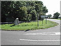
Millennium Stone
at the junction of Nottingham Road and Bleasby Road.This was the site of an old cross and so in 2000 Bleasby Parish set this stone here
Image: © Tom Courtney
Taken: 21 Aug 2005
0.13 miles
2
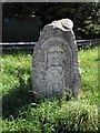
Bleasby Parish Millennium Stone
View from front
Image: © Tom Courtney
Taken: 21 Aug 2005
0.13 miles
3
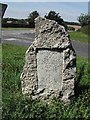
Bleasby Parish Millennium Stone
View from rear
Image: © Tom Courtney
Taken: 21 Aug 2005
0.13 miles
4
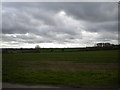
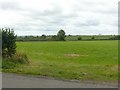
Across the fields north of Thurgarton
Seen from High Cross under threatening skies.
Image: © Richard Vince
Taken: 6 Apr 2014
0.19 miles
6
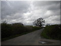
High Cross north of Thurgarton (1)
Looking towards the A612 under threatening skies.
Image: © Richard Vince
Taken: 6 Apr 2014
0.21 miles

8
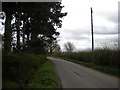
High Cross north of Thurgarton (2)
Looking towards Goverton and Bleasby.
Image: © Richard Vince
Taken: 6 Apr 2014
0.22 miles