IMAGES TAKEN NEAR TO
Bleasby, NOTTINGHAM, NG14 7FP
Introduction
This page details the photographs taken nearby to NG14 7FP by members of the Geograph project.
The Geograph project started in 2005 with the aim of publishing, organising and preserving representative images for every square kilometre of Great Britain, Ireland and the Isle of Man.

There are currently over 7.5m images from over14,400 individuals and you can help contribute to the project by visiting https://www.geograph.org.uk
Image Map
Images are licensed for reuse under creativecommons.org/licenses/by-sa/2.0
Notes
- Clicking on the map will re-center to the selected point.
- The higher the marker number, the further away the image location is from the centre of the postcode.
Image Listing (4 Images Found)
Images are licensed for reuse under creativecommons.org/licenses/by-sa/2.0
Image
Details
Distance
1
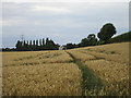
Wheatfield and Brickyard Farm
Seen from Gorsy Lane,
Image: © Jonathan Thacker
Taken: 21 Jul 2017
0.00 miles
2
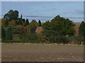
Brickyard Farm
Seen from the footpath alongside the railway, and largely hidden by trees. It's not clear whether this is still a working farm or now simply residential.
Image: © Alan Murray-Rust
Taken: 13 Oct 2009
0.02 miles
3
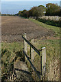
Footbridges
On a path alongside the railway east of Bleasby. The further footbridge marks a footpath junction; carry on and you will eventually get to Southwell; cross the railway and there is a choice of routes - back to Bleasby or on to Morton.
Image: © Alan Murray-Rust
Taken: 13 Oct 2009
0.19 miles
4
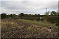
Link footpath between two footpaths to Bleasby
Image: © Chris
Taken: 19 Oct 2014
0.24 miles