IMAGES TAKEN NEAR TO
Hobsons Acre, NOTTINGHAM, NG14 7FF
Introduction
This page details the photographs taken nearby to Hobsons Acre, NG14 7FF by members of the Geograph project.
The Geograph project started in 2005 with the aim of publishing, organising and preserving representative images for every square kilometre of Great Britain, Ireland and the Isle of Man.

There are currently over 7.5m images from over14,400 individuals and you can help contribute to the project by visiting https://www.geograph.org.uk
Image Map
Images are licensed for reuse under creativecommons.org/licenses/by-sa/2.0
Notes
- Clicking on the map will re-center to the selected point.
- The higher the marker number, the further away the image location is from the centre of the postcode.
Image Listing (37 Images Found)
Images are licensed for reuse under creativecommons.org/licenses/by-sa/2.0
Image
Details
Distance
1
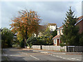
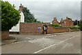
Main Street, Gunthorpe
At Bramley Close. The crenellated tower of Gunthorpe peeps above the trees.
Image: © Alan Murray-Rust
Taken: 16 Oct 2009
0.03 miles
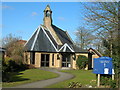
3
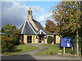
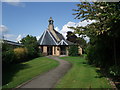
St John the Baptist
An unassuming, and according Pevsner, uninteresting small Victorian church with sympathetically designed modern vestibule and vestry.
Image: © Alan Murray-Rust
Taken: 16 Oct 2009
0.04 miles
4
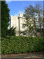
Gunthorpe Hall
The castellation and cement render appear to be an early 19th century addition to a Georgian house.
Image: © Alan Murray-Rust
Taken: 16 Oct 2009
0.04 miles
5
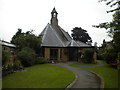
Church of St John the Baptist, Gunthorpe
A small church with a rather odd looking extension, in a cramped location just off Main Street.
Image: © Richard Vince
Taken: 24 Aug 2013
0.04 miles
6
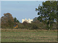
Gunthorpe Hall
The distinctive crenellations stand out above the surrounding trees.
Image: © Alan Murray-Rust
Taken: 16 Oct 2009
0.04 miles
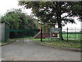
7
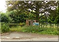
Gunthorpe Pumping Station
Recreating this 'First' for the square https://www.geograph.org.uk/photo/44237
Image: © Alan Murray-Rust
Taken: 13 Jul 2021
0.05 miles
8
Church of St John the Baptist, Gunthorpe
For details: http://southwellchurches.nottingham.ac.uk/gunthorpe/index.html
Image: © Tim Heaton
Taken: 7 Sep 2008
0.06 miles
9
Peck Lane, Gunthorpe
Recreating this 'First' for the square https://www.geograph.org.uk/photo/44231 . A new standard Nottinghamshire village notice board has been erected, and the road name sign has been moved.
Image: © Alan Murray-Rust
Taken: 13 Jul 2021
0.06 miles
10
Gunthorpe Pumping Station
situated at the top of Main Street near the junction Fearon Close
Image: © Tom Courtney
Taken: 28 Aug 2005
0.06 miles