IMAGES TAKEN NEAR TO
Main Street, NOTTINGHAM, NG14 7ED
Introduction
This page details the photographs taken nearby to Main Street, NG14 7ED by members of the Geograph project.
The Geograph project started in 2005 with the aim of publishing, organising and preserving representative images for every square kilometre of Great Britain, Ireland and the Isle of Man.

There are currently over 7.5m images from over14,400 individuals and you can help contribute to the project by visiting https://www.geograph.org.uk
Image Map
Images are licensed for reuse under creativecommons.org/licenses/by-sa/2.0
Notes
- Clicking on the map will re-center to the selected point.
- The higher the marker number, the further away the image location is from the centre of the postcode.
Image Listing (61 Images Found)
Images are licensed for reuse under creativecommons.org/licenses/by-sa/2.0
Image
Details
Distance
1
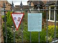
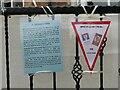
Caythorpe WW2 Village Trail, July 2021 ? No.13
Information relating to Warehouse Yard/The Croy.
Image: © Alan Murray-Rust
Taken: 13 Jul 2021
0.01 miles
2
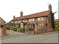
The Croy (formerly Warehouse Yard), Main Street, Caythorpe
A typical row of cottages at right angles to the village street on what would have been a narrow burgage plot, now combined. The large first floor windows are a reminder of the use of these cottages by framework knitters. There were formerly workshops opposite. See https://www.geograph.org.uk/photo/6899415 for more information.
Image: © Alan Murray-Rust
Taken: 15 Jul 2021
0.02 miles
4
Caythorpe WW2 Village Trail, July 2021 ? No.14
See https://www.geograph.org.uk/photo/1551419 and https://www.geograph.org.uk/photo/6899413
Image: © Alan Murray-Rust
Taken: 15 Jul 2021
0.03 miles
5
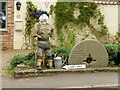
Land Amy
One of a series of World War 2 themed tableaux created as part of the village of Caythorpe's celebrations of 75 years from VE-Day in July 2021. These were postponed from 2020 due to the Covid-19 pandemic. The tableau shows a Land Army girl, named Amy. https://en.wikipedia.org/wiki/Women%27s_Land_Army
Image: © Alan Murray-Rust
Taken: 13 Jul 2021
0.03 miles
6
Caythorpe WW2 Village Trail, July 2021 ? No.15
See also https://www.geograph.org.uk/photo/1551425
Image: © Alan Murray-Rust
Taken: 15 Jul 2021
0.04 miles
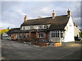
8
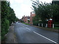
Black Horse, Caythorpe
The front of this old village pub, still currently in business.
Image: © Alan Murray-Rust
Taken: 16 Oct 2009
0.04 miles
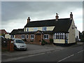
9
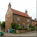
Ivy Cottage, Main Street, Caythorpe
Late 18th century, probably a small farmhouse, Listed Grade II.
Subsequently a beer house, a Calvinist meeting place and latterly the village Post Office (note the post box in the wall). See https://www.geograph.org.uk/photo/6899415
Image: © Alan Murray-Rust
Taken: 15 Jul 2021
0.04 miles
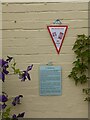
10
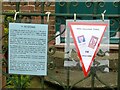
Caythorpe WW2 Village Trail, July 2021 ? No.12
Information relating to Ivy Cottage.
Image: © Alan Murray-Rust
Taken: 13 Jul 2021
0.04 miles